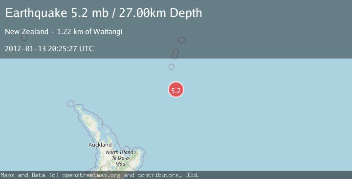
Earthquake SOUTH OF KERMADEC ISLANDS
Fri, 13 Jan 2012 20:25:27 GMT
Time14 years ago
Location
-33.0800, -178.3800
Depth
27.0 KM
Event Summary
A 5.2 magnitude earthquake struck on SOUTH OF KERMADEC ISLANDS, at Fri, 13 Jan 2012 20:25:27 GMT. Depth: 27km. Reviewed by EMSC seismologists, this moderate quake occurred at a magnitude type of mb.
Magnitude
5.2
mb
Source
EMSC
Intensity
-
Agency Reports
1 Sources| Source | Magnitude | Depth | Time |
|---|---|---|---|
| EMSCPrimary | 5.2 | 27 km | 14 years ago |
Earthquake Details
AutomaticEvent IDemsc_EMSC_20120113_0000068
Tsunami PotentialNo
Magnitude Typemb
Nearest Places
- Star of Bengal Bank99.9 km
- Haungaroa Seamount127.8 km
- Speight Knoll136.8 km
- Oliver Knoll142.9 km
- Kuiwai Seamount143.8 km
Comments
Join the discussion about this event.
Latest Earthquakes
1.5Mag
Tarapaca, Chile
Time6 minutes ago
Depth12.94 km
SourceVYT (Automatic)
2.0Mag
Poland
Time8 minutes ago
Depth6.35 km
SourceVYT (Automatic)
3.7Mag
north of Halmahera, Indonesia
Time9 minutes ago
Depth1.22 km
SourceVYT (Automatic)
3.1Mag
Halmahera, Indonesia
Time11 minutes ago
Depth22.95 km
SourceVYT (Automatic)
2.4Mag
Fox Islands, Aleutian Islands, Alaska
Time24 minutes ago
Depth14.04 km
SourceVYT (Automatic)
Nearby Earthquakes
5.1Mag
SOUTH OF KERMADEC ISLANDS
Time18 years ago
Depth10.00 km
SourceEMSC (Automatic)
5.0Mag
SOUTH OF KERMADEC ISLANDS
Time10 years ago
Depth10.00 km
SourceEMSC (Automatic)
5.4Mag
SOUTH OF KERMADEC ISLANDS
Time14 years ago
Depth2.00 km
SourceEMSC (Automatic)
5.1Mag
SOUTH OF KERMADEC ISLANDS
Time10 years ago
Depth10.00 km
SourceEMSC (Automatic)
5.1Mag
SOUTH OF KERMADEC ISLANDS
Time4 years ago
Depth10.00 km
SourceNEIC (Automatic)