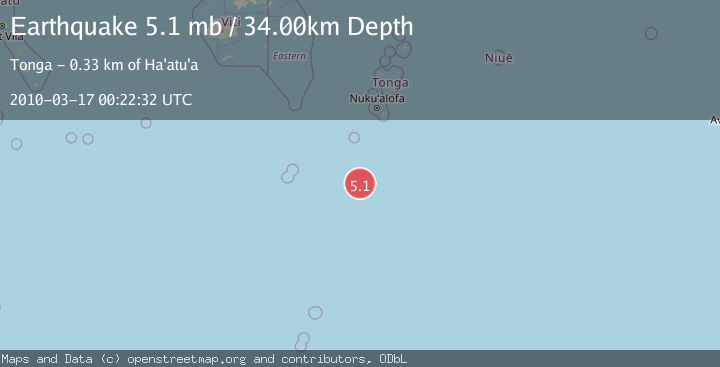
Earthquake SOUTH OF TONGA
Wed, 17 Mar 2010 00:22:32 GMT
Time15 years ago
Location
-24.1900, -175.9400
Depth
34.0 KM
Event Summary
A 5.1 magnitude earthquake struck on SOUTH OF TONGA, at Wed, 17 Mar 2010 00:22:32 GMT. Depth: 34km. Reviewed by NEIC seismologists, this moderate quake occurred at a magnitude type of mb.
Magnitude
5.1
mb
Source
NEIC
Intensity
-
Agency Reports
1 Sources| Source | Magnitude | Depth | Time |
|---|---|---|---|
| NEICPrimary | 5.1 | 34 km | 15 years ago |
Earthquake Details
AutomaticEvent IDemsc_NEIC_20100317_0000003
Tsunami PotentialNo
Magnitude Typemb
Nearest Places
- 160.1 km
- 160.1 km
- 160.1 km
- 208.2 km
- 217.0 km
Comments
Join the discussion about this event.
Latest Earthquakes
2.5Mag
South of Java, Indonesia
Time11 minutes ago
Depth162.67 km
SourceBMKG
0.6Mag
9 km NW of The Geysers, CA
Time15 minutes ago
Depth2.06 km
SourceUSGS (Automatic)
1.2Mag
WESTERN TURKEY
Time21 minutes ago
Depth7.60 km
SourceAFAD (Automatic)
3.5Mag
Flores region, Indonesia
Time23 minutes ago
Depth638.55 km
SourceVYT (Automatic)
3.2Mag
South of Java, Indonesia
Time24 minutes ago
Depth64.99 km
SourceBMKG
Nearby Earthquakes
5.2Mag
SOUTH OF TONGA
Time13 years ago
Depth60.00 km
SourceEMSC (Automatic)
5.4Mag
SOUTH OF FIJI ISLANDS
Time6 months ago
Depth10.00 km
SourceEMSC (Automatic)
5.1Mag
SOUTH OF TONGA
Time13 years ago
Depth42.00 km
SourceEMSC (Automatic)
5.1Mag
SOUTH OF TONGA
Time7 years ago
Depth10.00 km
SourceEMSC (Automatic)
5.3Mag
SOUTH OF TONGA
Time13 years ago
Depth2.00 km
SourceEMSC (Automatic)