Earthquake 86 km NNW of Charlotte Amalie, U.S. Virgin Islands
Sat, 14 Feb 2026 02:59:43 GMT
Time6 days ago
Location
19.1021, -65.1020
Depth
35.0 KM
Event Summary
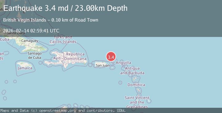
A 3.4 magnitude earthquake struck on 86 km NNW of Charlotte Amalie, U.S. Virgin Islands, at Sat, 14 Feb 2026 02:59:43 GMT. Depth: 35km. Reviewed by USGS seismologists, this minor quake occurred at a magnitude type of ml.
Magnitude
3.4
ml
Source
USGS
Intensity
-
Agency Reports
2 Sources| Source | Magnitude | Depth | Time |
|---|---|---|---|
| USGSPrimary | 2.9 | 35 km | 6 days ago |
| PR | 3.4 | 23 km | 6 days ago |
Earthquake Details
ConfirmedEvent IDusgs_us6000s958
Tsunami PotentialNo
Magnitude Typeml
Nearest Places
- Anegada Canyon57.1 km
- Whale Banks61.5 km
- Molinos Canyon61.8 km
- Turtle Head64.3 km
- Barracouta Banks64.5 km
Comments
Join the discussion about this event.
Latest Earthquakes
1.5Mag
Tarapaca, Chile
Time6 minutes ago
Depth12.94 km
SourceVYT (Automatic)
2.0Mag
Poland
Time7 minutes ago
Depth6.35 km
SourceVYT (Automatic)
3.7Mag
north of Halmahera, Indonesia
Time8 minutes ago
Depth1.22 km
SourceVYT (Automatic)
3.1Mag
Halmahera, Indonesia
Time11 minutes ago
Depth22.95 km
SourceVYT (Automatic)
2.4Mag
Fox Islands, Aleutian Islands, Alaska
Time23 minutes ago
Depth14.04 km
SourceVYT (Automatic)
Nearby Earthquakes
3.0Mag
VIRGIN ISLANDS REGION
Time9 years ago
Depth29.00 km
SourceNEIR (Automatic)
3.0Mag
VIRGIN ISLANDS REGION
Time8 years ago
Depth36.00 km
SourceNEIR (Automatic)
3.0Mag
VIRGIN ISLANDS REGION
Time8 years ago
Depth31.00 km
SourceNEIR (Automatic)
3.0Mag
VIRGIN ISLANDS REGION
Time7 years ago
Depth40.00 km
SourceNEIR (Automatic)
3.0Mag
VIRGIN ISLANDS REGION
Time12 years ago
Depth45.00 km
SourceNEIR (Automatic)