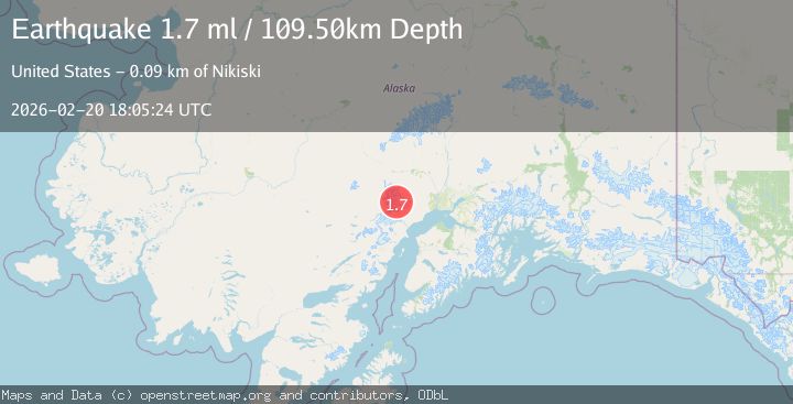
Earthquake Southern Alaska
Fri, 20 Feb 2026 18:05:25 GMT
Time1 hour ago
Location
61.5192, -152.6509
Depth
91.3 KM
Event Summary
A 1.7 magnitude earthquake struck on Southern Alaska, at Fri, 20 Feb 2026 18:05:25 GMT. Depth: 91.30859375km. Reviewed by VYT seismologists, this minor quake occurred at a magnitude type of earthquake.
Magnitude
1.7
earthquake
Source
VYT
Intensity
-
Agency Reports
2 Sources| Source | Magnitude | Depth | Time |
|---|---|---|---|
| VYTPrimary | 1.6 | 91 km | 1 hour ago |
| USGS | 1.7 | 110 km | 1 hour ago |
Earthquake Details
AutomaticEvent IDvyt_3qvrxumhw7hmg
Tsunami PotentialNo
Magnitude Typeearthquake
Nearest Places
- North Twin Glacier3.8 km
- South Twin Glacier9.5 km
- Mount Gerdine12.9 km
- Hayes Volcano13.7 km
- Harpoon Glacier17.2 km
Comments
Join the discussion about this event.
Latest Earthquakes
2.7Mag
Halmahera, Indonesia
Time1 hour ago
Depth15.96 km
SourceBMKG
1.4Mag
14 km NNW of Stanton, Texas
Time1 hour ago
Depth3.64 km
SourceUSGS (Automatic)
2.6Mag
Java, Indonesia
Time1 hour ago
Depth12.69 km
SourceBMKG
2.2Mag
Southern Sumatra, Indonesia
Time1 hour ago
Depth24.35 km
SourceBMKG
1.9Mag
60 km S of Whites City, New Mexico
Time1 hour ago
Depth5.71 km
SourceUSGS (Automatic)
Nearby Earthquakes
1.1Mag
Southern Alaska
Time1 week ago
Depth12.94 km
SourceVYT (Automatic)
1.1Mag
Southern Alaska
Time1 week ago
Depth0.00 km
SourceVYT (Automatic)
3.0Mag
SOUTHERN ALASKA
Time5 years ago
Depth133.00 km
SourceNEIR (Automatic)
2.4Mag
71 km SW of Skwentna, Alaska
Time1 week ago
Depth5.00 km
SourceUSGS (Automatic)
3.0Mag
SOUTHERN ALASKA
Time4 years ago
Depth5.00 km
SourceNEIC (Automatic)