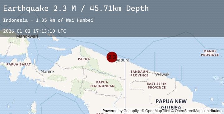
Earthquake Near North Coast of West Papua
Fri, 02 Jan 2026 17:13:10 GMT
Time4 hours ago
Location
-2.3399, 140.0766
Depth
45.7 KM
Event Summary
A 2.3 magnitude earthquake struck on Near North Coast of West Papua, at Fri, 02 Jan 2026 17:13:10 GMT. Depth: 45.710125km. Reviewed by BMKG seismologists, this minor quake occurred at a magnitude type of M.
Magnitude
2.3
M
Source
BMKG
Intensity
-
Agency Reports
1 Sources| Source | Magnitude | Depth | Time |
|---|---|---|---|
| BMKGPrimary | 2.3 | 46 km | 4 hours ago |
Earthquake Details
AutomaticEvent IDbmg2026addp
Tsunami PotentialNo
Magnitude TypeM
Nearest Places
- Wai Humbei1.4 km
- Moaif3.2 km
- Tanjung Kamadara4.8 km
- Sungai Moaif4.9 km
- Sungai Grime5.1 km
Comments
Join the discussion about this event.
Latest Earthquakes
4.3Mag
Mindanao, Philippines
Time4 hours ago
Depth10.00 km
SourceBMKG (Automatic)
2.4Mag
WESTERN TURKEY
Time4 hours ago
Depth8.20 km
SourceEMSC (Automatic)
4.0Mag
GUERRERO, MEXICO
Time4 hours ago
Depth7.70 km
SourceUNM (Automatic)
2.9Mag
TARAPACA, CHILE
Time4 hours ago
Depth112.80 km
SourceCSN (Automatic)
4.1Mag
GUERRERO, MEXICO
Time4 hours ago
Depth7.50 km
SourceUNM (Automatic)
Nearby Earthquakes
No significant earthquakes nearby recently.