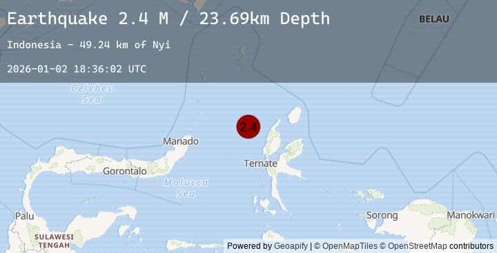
Earthquake Northern Molucca Sea
Fri, 02 Jan 2026 18:36:02 GMT
Time5 hours ago
Location
1.9510, 126.9994
Depth
23.7 KM
Event Summary
A 2.4 magnitude earthquake struck on Northern Molucca Sea, at Fri, 02 Jan 2026 18:36:02 GMT. Depth: 23.692274km. Reviewed by BMKG seismologists, this minor quake occurred at a magnitude type of M.
Magnitude
2.4
M
Source
BMKG
Intensity
-
Agency Reports
1 Sources| Source | Magnitude | Depth | Time |
|---|---|---|---|
| BMKGPrimary | 2.4 | 24 km | 5 hours ago |
Earthquake Details
AutomaticEvent IDbmg2026adgi
Tsunami PotentialNo
Magnitude TypeM
Nearest Places
- Nyi49.2 km
- Nusa Sidanga62.7 km
- Nusa Nyaolaka63.1 km
- Nusa Sosota63.4 km
- Pulau Tutu63.4 km
Comments
Join the discussion about this event.
Latest Earthquakes
5.2Mag
Banda Sea
Time5 hours ago
Depth76.51 km
SourceBMKG (Automatic)
3.1Mag
MINDANAO, PHILIPPINES
Time5 hours ago
Depth20.00 km
SourcePIVS (Automatic)
2.7Mag
CANARY ISLANDS, SPAIN REGION
Time6 hours ago
Depth0.00 km
SourceIGN (Automatic)
1.0Mag
33 km SE of Minto, Alaska
Time6 hours ago
Depth0.20 km
SourceUSGS (Automatic)
1.7Mag
53 km WNW of Beatty, Nevada
Time6 hours ago
Depth4.04 km
SourceUSGS (Automatic)
Nearby Earthquakes
2.8Mag
Halmahera, Indonesia
Time14 hours ago
Depth17.66 km
SourceBMKG (Automatic)
3.2Mag
Northern Molucca Sea
Time17 hours ago
Depth10.00 km
SourceBMKG (Automatic)
4.0Mag
Halmahera, Indonesia
Time22 hours ago
Depth50.87 km
SourceBMKG (Automatic)
4.6Mag
Northern Molucca Sea
Time1 day ago
Depth71.15 km
SourceBMKG (Automatic)