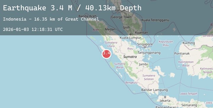
Earthquake Northern Sumatra, Indonesia
Sat, 03 Jan 2026 12:18:32 GMT
Time3 days ago
Location
0.2759, 98.2760
Depth
17.7 KM
Event Summary
A 3.6 magnitude earthquake struck on Northern Sumatra, Indonesia, at Sat, 03 Jan 2026 12:18:32 GMT. Depth: 17.683733km. Reviewed by BMKG seismologists, this minor quake occurred at a magnitude type of M.
Magnitude
3.6
M
Source
BMKG
Intensity
-
Agency Reports
1 Sources| Source | Magnitude | Depth | Time |
|---|---|---|---|
| BMKGPrimary | 3.6 | 18 km | 3 days ago |
Earthquake Details
AutomaticEvent IDbmg2026aepj
Tsunami PotentialNo
Magnitude TypeM
Nearest Places
- Desa Zia Biang24.6 km
- Pulau Biang25.0 km
- Desa Limo Biang25.1 km
- Pulau Memong25.1 km
- Desa Memong25.2 km
Comments
Join the discussion about this event.
Latest Earthquakes
1.1Mag
26 km ENE of McKinney Acres, Texas
Time3 days ago
Depth3.84 km
SourceUSGS (Automatic)
2.1Mag
FRANCE
Time3 days ago
Depth0.00 km
SourceReNaSS (Automatic)
2.0Mag
AEGEAN SEA
Time3 days ago
Depth2.70 km
SourceEMSC (Automatic)
1.3Mag
WESTERN TURKEY
Time3 days ago
Depth10.20 km
SourceAFAD (Automatic)
2.3Mag
7 km NNW of Nikolaevsk, Alaska
Time3 days ago
Depth45.20 km
SourceUSGS (Automatic)
Nearby Earthquakes
No significant earthquakes nearby recently.