Earthquake Philippine Islands Region
Sat, 03 Jan 2026 20:46:56 GMT
Time4 days ago
Location
5.0092, 127.3848
Depth
117.9 KM
Event Summary
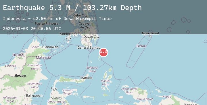
A 4.8 magnitude earthquake struck on Philippine Islands Region, at Sat, 03 Jan 2026 20:46:56 GMT. Depth: 117.857414km. Reviewed by BMKG seismologists, this light quake occurred at a magnitude type of M.
Magnitude
4.8
M
Source
BMKG
Intensity
-
Agency Reports
1 Sources| Source | Magnitude | Depth | Time |
|---|---|---|---|
| BMKGPrimary | 4.8 | 118 km | 4 days ago |
Earthquake Details
AutomaticEvent IDbmg2026afgd
Tsunami PotentialNo
Magnitude TypeM
Nearest Places
- Desa Marampit Timur39.1 km
- Desa Marampit39.6 km
- Kecamatan Nanusa40.3 km
- Pulau Marampit40.4 km
- Desa Dampulis40.5 km
Comments
Join the discussion about this event.
Latest Earthquakes
2.0Mag
NEW MEXICO
Time4 days ago
Depth7.40 km
SourceTX (Automatic)
1.5Mag
56 km SSW of Goldfield, Nevada
Time4 days ago
Depth5.49 km
SourceUSGS (Automatic)
1.7Mag
26 km NW of Susitna, Alaska
Time4 days ago
Depth59.70 km
SourceUSGS (Automatic)
2.8Mag
COQUIMBO, CHILE
Time4 days ago
Depth28.70 km
SourceCSN (Automatic)
3.7Mag
MINDANAO, PHILIPPINES
Time4 days ago
Depth24.00 km
SourcePIVS (Automatic)