Earthquake Southern Sumatra, Indonesia
Sun, 04 Jan 2026 04:42:24 GMT
Time5 days ago
Location
-1.7017, 101.1982
Depth
4.5 KM
Event Summary
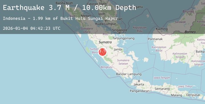
A 3.0 magnitude earthquake struck on Southern Sumatra, Indonesia, at Sun, 04 Jan 2026 04:42:24 GMT. Depth: 4.528102km. Reviewed by BMKG seismologists, this minor quake occurred at a magnitude type of M.
Magnitude
3.0
M
Source
BMKG
Intensity
-
Agency Reports
1 Sources| Source | Magnitude | Depth | Time |
|---|---|---|---|
| BMKGPrimary | 3.0 | 5 km | 5 days ago |
Earthquake Details
AutomaticEvent IDbmg2026afvv
Tsunami PotentialNo
Magnitude TypeM
Nearest Places
- Bukit Hulu Sungai Kapur2.0 km
- Gunung Terembun2.1 km
- Gunung Kapur3.6 km
- Pondok Bunga5.2 km
- Desa Kebun Baru5.7 km
Comments
Join the discussion about this event.
Latest Earthquakes
2.8Mag
Borneo
Time5 days ago
Depth2.72 km
SourceBMKG (Automatic)
1.3Mag
4 km W of Cobb, CA
Time5 days ago
Depth1.97 km
SourceUSGS (Automatic)
2.1Mag
Near North Coast of West Papua
Time5 days ago
Depth10.00 km
SourceBMKG (Automatic)
1.6Mag
CANARY ISLANDS, SPAIN REGION
Time5 days ago
Depth16.70 km
SourceIGN (Automatic)
1.0Mag
9 km NE of Julian, CA
Time5 days ago
Depth5.56 km
SourceUSGS (Automatic)
Nearby Earthquakes
No significant earthquakes nearby recently.