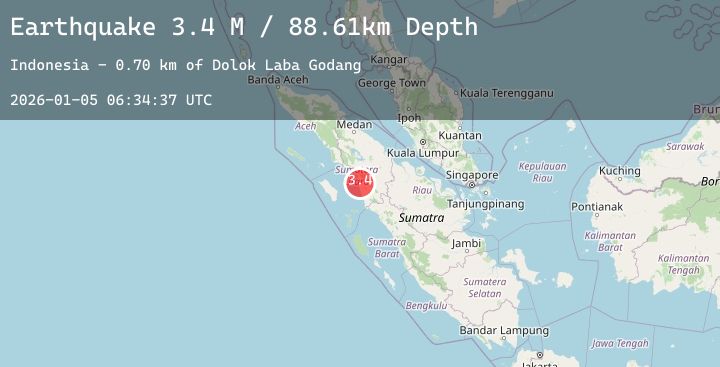
Earthquake Northern Sumatra, Indonesia
Mon, 05 Jan 2026 06:34:36 GMT
Time3 days ago
Location
1.2341, 98.8056
Depth
83.4 KM
Event Summary
A 3.2 magnitude earthquake struck on Northern Sumatra, Indonesia, at Mon, 05 Jan 2026 06:34:36 GMT. Depth: 83.427444km. Reviewed by BMKG seismologists, this minor quake occurred at a magnitude type of M.
Magnitude
3.2
M
Source
BMKG
Intensity
-
Agency Reports
1 Sources| Source | Magnitude | Depth | Time |
|---|---|---|---|
| BMKGPrimary | 3.2 | 83 km | 3 days ago |
Earthquake Details
AutomaticEvent IDbmg2026ahva
Tsunami PotentialNo
Magnitude TypeM
Nearest Places
- Pulau Ilir4.5 km
- Aek Marait Gadang7.1 km
- Rodang Bantot7.3 km
- Gunung Batumarumpak7.4 km
- Batumundam7.6 km
Comments
Join the discussion about this event.
Latest Earthquakes
2.3Mag
Java, Indonesia
Time3 days ago
Depth32.84 km
SourceBMKG (Automatic)
2.9Mag
OFFSHORE ATACAMA, CHILE
Time3 days ago
Depth31.40 km
SourceCSN (Automatic)
0.8Mag
18 km E of Julian, CA
Time3 days ago
Depth6.30 km
SourceUSGS (Automatic)
3.1Mag
OFFSHORE EL SALVADOR
Time3 days ago
Depth37.00 km
SourceINET (Automatic)
3.1Mag
Banda Sea
Time3 days ago
Depth29.82 km
SourceBMKG (Automatic)