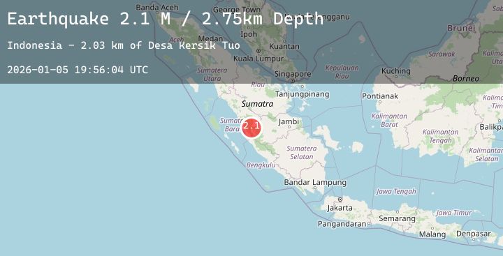
Earthquake Southern Sumatra, Indonesia
Mon, 05 Jan 2026 19:56:02 GMT
Time3 days ago
Location
-1.7109, 101.1213
Depth
10.0 KM
Event Summary
A 2.4 magnitude earthquake struck on Southern Sumatra, Indonesia, at Mon, 05 Jan 2026 19:56:02 GMT. Depth: 10km. Reviewed by BMKG seismologists, this minor quake occurred at a magnitude type of M.
Magnitude
2.4
M
Source
BMKG
Intensity
-
Agency Reports
1 Sources| Source | Magnitude | Depth | Time |
|---|---|---|---|
| BMKGPrimary | 2.4 | 10 km | 3 days ago |
Earthquake Details
AutomaticEvent IDbmg2026aivm
Tsunami PotentialNo
Magnitude TypeM
Nearest Places
- Gunung Patahsembilan3.4 km
- Gunung Terembun6.8 km
- Gunung Kapur7.0 km
- Bukit Hulu Sungai Kapur7.0 km
- Desa Kebun Baru7.8 km
Comments
Join the discussion about this event.
Latest Earthquakes
1.8Mag
5 km N of Dublin, CA
Time3 days ago
Depth7.63 km
SourceUSGS (Automatic)
2.0Mag
68 km ESE of Cantwell, Alaska
Time3 days ago
Depth6.30 km
SourceUSGS (Automatic)
0.7Mag
8 km SW of Idyllwild, CA
Time3 days ago
Depth14.29 km
SourceUSGS (Automatic)
4.1Mag
PHILIPPINE ISLANDS REGION
Time3 days ago
Depth10.00 km
SourcePIVS (Automatic)
3.3Mag
JUJUY, ARGENTINA
Time3 days ago
Depth232.60 km
SourceCSN (Automatic)
Nearby Earthquakes
No significant earthquakes nearby recently.