Earthquake Minahassa Peninsula, Sulawesi
Wed, 07 Jan 2026 05:09:45 GMT
Time2 days ago
Location
0.5524, 119.6569
Depth
12.4 KM
Event Summary
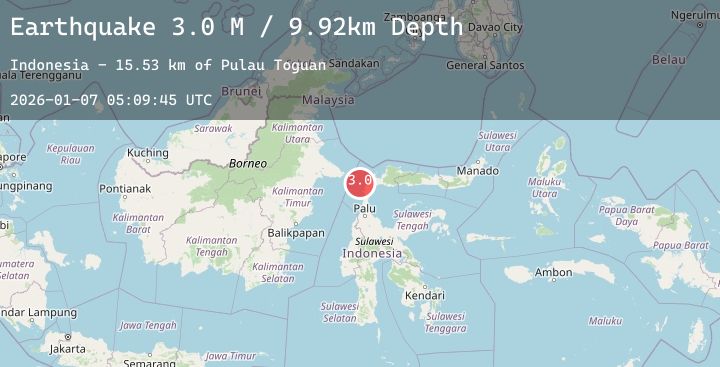
A 3.0 magnitude earthquake struck on Minahassa Peninsula, Sulawesi, at Wed, 07 Jan 2026 05:09:45 GMT. Depth: 12.376101km. Reviewed by BMKG seismologists, this minor quake occurred at a magnitude type of M.
Magnitude
3.0
M
Source
BMKG
Intensity
-
Agency Reports
1 Sources| Source | Magnitude | Depth | Time |
|---|---|---|---|
| BMKGPrimary | 3.0 | 12 km | 2 days ago |
Earthquake Details
AutomaticEvent IDbmg2026aljg
Tsunami PotentialNo
Magnitude TypeM
Nearest Places
- Pulau Toguan15.5 km
- North Watcher Lighthouse (historical)15.6 km
- Alau Togoge22.9 km
- Pulau Maputi23.0 km
- Maputi23.3 km
Comments
Join the discussion about this event.
Latest Earthquakes
3.1Mag
Timor Region
Time2 days ago
Depth49.31 km
SourceBMKG (Automatic)
2.4Mag
Java, Indonesia
Time2 days ago
Depth23.09 km
SourceBMKG (Automatic)
1.3Mag
1 km NNE of The Geysers, CA
Time2 days ago
Depth0.52 km
SourceUSGS (Automatic)
3.8Mag
HOKKAIDO, JAPAN REGION
Time2 days ago
Depth60.00 km
SourceJMA (Automatic)
1.1Mag
FINLAND
Time2 days ago
Depth0.00 km
SourceSNSN (Automatic)
Nearby Earthquakes
No significant earthquakes nearby recently.