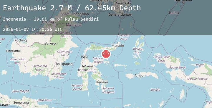
Earthquake Minahassa Peninsula, Sulawesi
Wed, 07 Jan 2026 14:30:34 GMT
Time1 day ago
Location
-0.1539, 123.2351
Depth
71.9 KM
Event Summary
A 2.7 magnitude earthquake struck on Minahassa Peninsula, Sulawesi, at Wed, 07 Jan 2026 14:30:34 GMT. Depth: 71.88726km. Reviewed by BMKG seismologists, this minor quake occurred at a magnitude type of M.
Magnitude
2.7
M
Source
BMKG
Intensity
-
Agency Reports
1 Sources| Source | Magnitude | Depth | Time |
|---|---|---|---|
| BMKGPrimary | 2.7 | 72 km | 1 day ago |
Earthquake Details
AutomaticEvent IDbmg2026ambu
Tsunami PotentialNo
Magnitude TypeM
Nearest Places
- Pulau Mantawalu Daka43.0 km
- Pulau Mantawalu Ise46.5 km
- Kaunyo Malik47.4 km
- Maleh47.4 km
- Kaunyo Bombon47.5 km
Comments
Join the discussion about this event.
Latest Earthquakes
2.0Mag
48 km N of Sutton-Alpine, Alaska
Time1 day ago
Depth25.00 km
SourceUSGS (Automatic)
2.7Mag
South of Java, Indonesia
Time1 day ago
Depth13.49 km
SourceBMKG (Automatic)
2.3Mag
South of Sumbawa, Indonesia
Time1 day ago
Depth10.00 km
SourceBMKG (Automatic)
2.4Mag
WESTERN TEXAS
Time1 day ago
Depth3.70 km
SourceTX (Automatic)
2.8Mag
Bali Region, Indonesia
Time1 day ago
Depth40.59 km
SourceBMKG (Automatic)