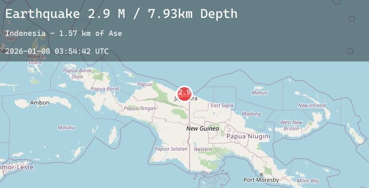
Earthquake Near North Coast of West Papua
Thu, 08 Jan 2026 03:54:42 GMT
Time2 days ago
Location
-2.6324, 140.6014
Depth
7.9 KM
Event Summary
A 2.7 magnitude earthquake struck on Near North Coast of West Papua, at Thu, 08 Jan 2026 03:54:42 GMT. Depth: 7.932188km. Reviewed by BMKG seismologists, this minor quake occurred at a magnitude type of M.
Magnitude
2.7
M
Source
BMKG
Intensity
-
Agency Reports
1 Sources| Source | Magnitude | Depth | Time |
|---|---|---|---|
| BMKGPrimary | 2.7 | 8 km | 2 days ago |
Earthquake Details
AutomaticEvent IDbmg2026ancg
Tsunami PotentialNo
Magnitude TypeM
Nearest Places
- Kampung Ayapo1.0 km
- Ase2.4 km
- Distrik Sentani Timur2.6 km
- Kampung Yoka3.4 km
- Pulau Ase4.0 km
Comments
Join the discussion about this event.
Latest Earthquakes
3.8Mag
HOKKAIDO, JAPAN REGION
Time2 days ago
Depth80.00 km
SourceJMA (Automatic)
1.1Mag
21 km NW of Stanton, Texas
Time2 days ago
Depth3.90 km
SourceUSGS (Automatic)
2.8Mag
HAITI REGION
Time2 days ago
Depth9.00 km
SourceAYIT (Automatic)
2.4Mag
Flores Region, Indonesia
Time2 days ago
Depth14.64 km
SourceBMKG (Automatic)
1.5Mag
57 km S of Whites City, New Mexico
Time2 days ago
Depth6.93 km
SourceUSGS (Automatic)