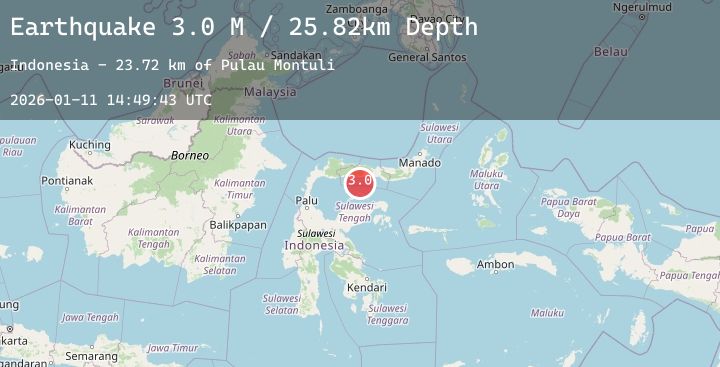
Earthquake Minahassa Peninsula, Sulawesi
Sun, 11 Jan 2026 14:49:43 GMT
Time1 day ago
Location
0.2039, 122.2284
Depth
25.8 KM
Event Summary
A 2.3 magnitude earthquake struck on Minahassa Peninsula, Sulawesi, at Sun, 11 Jan 2026 14:49:43 GMT. Depth: 25.820131km. Reviewed by BMKG seismologists, this minor quake occurred at a magnitude type of M.
Magnitude
2.3
M
Source
BMKG
Intensity
-
Agency Reports
1 Sources| Source | Magnitude | Depth | Time |
|---|---|---|---|
| BMKGPrimary | 2.3 | 26 km | 1 day ago |
Earthquake Details
AutomaticEvent IDbmg2026atkj
Tsunami PotentialNo
Magnitude TypeM
Nearest Places
- Pulau Montuli23.7 km
- Pulau Bitila25.1 km
- Pulau Telefoa27.1 km
- Wulungiyo Bulooliyo29.8 km
- Lito Molopinggulo30.2 km
Comments
Join the discussion about this event.
Latest Earthquakes
2.9Mag
Southern Sumatra, Indonesia
Time1 day ago
Depth30.90 km
SourceBMKG (Automatic)
1.9Mag
20 km E of Little Lake, CA
Time1 day ago
Depth1.46 km
SourceUSGS (Automatic)
1.1Mag
5 km NW of The Geysers, CA
Time1 day ago
Depth3.41 km
SourceUSGS (Automatic)
1.2Mag
WESTERN TURKEY
Time1 day ago
Depth7.10 km
SourceAFAD (Automatic)
2.1Mag
Sumba Region, Indonesia
Time1 day ago
Depth48.66 km
SourceBMKG (Automatic)
Nearby Earthquakes
2.5Mag
Minahassa Peninsula, Sulawesi
Time1 day ago
Depth105.22 km
SourceBMKG (Automatic)
3.4Mag
Minahassa Peninsula, Sulawesi
Time1 day ago
Depth74.44 km
SourceBMKG (Automatic)
2.7Mag
Minahassa Peninsula, Sulawesi
Time1 day ago
Depth8.25 km
SourceBMKG (Automatic)
2.0Mag
Minahassa Peninsula, Sulawesi
Time1 day ago
Depth11.50 km
SourceBMKG (Automatic)
2.3Mag
Minahassa Peninsula, Sulawesi
Time1 day ago
Depth104.71 km
SourceBMKG (Automatic)