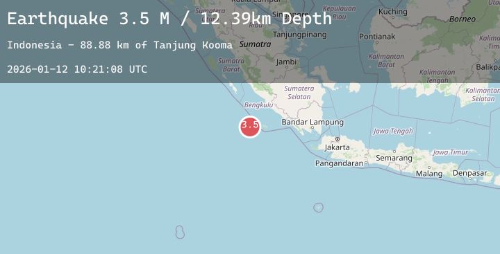
Earthquake Southwest of Sumatra, Indonesia
Mon, 12 Jan 2026 10:21:09 GMT
Time3 hours ago
Location
-5.4955, 101.2674
Depth
27.2 KM
Event Summary
A 3.5 magnitude earthquake struck on Southwest of Sumatra, Indonesia, at Mon, 12 Jan 2026 10:21:09 GMT. Depth: 27.240929km. Reviewed by BMKG seismologists, this minor quake occurred at a magnitude type of M.
Magnitude
3.5
M
Source
BMKG
Intensity
-
Agency Reports
1 Sources| Source | Magnitude | Depth | Time |
|---|---|---|---|
| BMKGPrimary | 3.5 | 27 km | 3 hours ago |
Earthquake Details
AutomaticEvent IDbmg2026auxa
Tsunami PotentialNo
Magnitude TypeM
Nearest Places
- Tanjung Kooma94.1 km
- Gunung Dupaaube96.5 km
- Desa Banjar Sari98.2 km
- Batang Mea99.8 km
- Sungai Hubaje101.1 km
Comments
Join the discussion about this event.
Latest Earthquakes
1.8Mag
9 km NNE of Banning, CA
Time3 hours ago
Depth18.03 km
SourceUSGS (Automatic)
1.5Mag
60 km S of Whites City, New Mexico
Time3 hours ago
Depth5.79 km
SourceUSGS (Automatic)
2.0Mag
Sumbawa Region, Indonesia
Time3 hours ago
Depth18.61 km
SourceBMKG (Automatic)
1.6Mag
CENTRAL TURKEY
Time3 hours ago
Depth7.00 km
SourceAFAD (Automatic)
3.0Mag
Java, Indonesia
Time3 hours ago
Depth43.49 km
SourceBMKG (Automatic)
Nearby Earthquakes
No significant earthquakes nearby recently.