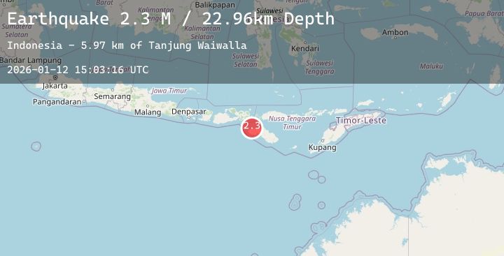
Earthquake Sumba Region, Indonesia
Mon, 12 Jan 2026 15:03:16 GMT
Time10 hours ago
Location
-9.3193, 119.2041
Depth
37.8 KM
Event Summary
A 2.5 magnitude earthquake struck on Sumba Region, Indonesia, at Mon, 12 Jan 2026 15:03:16 GMT. Depth: 37.84409km. Reviewed by BMKG seismologists, this minor quake occurred at a magnitude type of M.
Magnitude
2.5
M
Source
BMKG
Intensity
-
Agency Reports
1 Sources| Source | Magnitude | Depth | Time |
|---|---|---|---|
| BMKGPrimary | 2.5 | 38 km | 10 hours ago |
Earthquake Details
AutomaticEvent IDbmg2026avgi
Tsunami PotentialNo
Magnitude TypeM
Nearest Places
- Tanjung Waiwalla5.3 km
- Sungai Newa5.4 km
- Tanjung Oro6.1 km
- Teluk Waikelo6.9 km
- Loko Tuba7.7 km
Comments
Join the discussion about this event.
Latest Earthquakes
4.1Mag
NEAR EAST COAST OF HONSHU, JAPAN
Time10 hours ago
Depth50.00 km
SourceJMA (Automatic)
2.2Mag
SPAIN
Time10 hours ago
Depth0.00 km
SourceIGN (Automatic)
3.1Mag
Sunda Strait, Indonesia
Time10 hours ago
Depth23.57 km
SourceBMKG (Automatic)
0.3Mag
3 km WNW of Cobb, CA
Time10 hours ago
Depth-0.91 km
SourceUSGS (Automatic)
3.0Mag
SOUTHERN GREECE
Time11 hours ago
Depth8.10 km
SourceEMSC (Automatic)