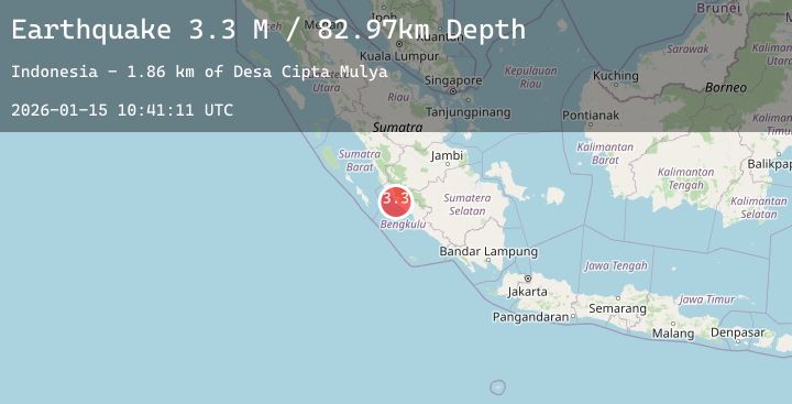
Earthquake Southern Sumatra, Indonesia
Thu, 15 Jan 2026 10:41:11 GMT
Time4 hours ago
Location
-3.0444, 101.6013
Depth
84.6 KM
Event Summary
A 3.4 magnitude earthquake struck on Southern Sumatra, Indonesia, at Thu, 15 Jan 2026 10:41:11 GMT. Depth: 84.602921km. Reviewed by BMKG seismologists, this minor quake occurred at a magnitude type of M.
Magnitude
3.4
M
Source
BMKG
Intensity
-
Agency Reports
2 Sources| Source | Magnitude | Depth | Time |
|---|---|---|---|
| BMKGPrimary | 3.4 | 85 km | 4 hours ago |
| BMKGPrimary | 3.2 | 68 km | 4 hours ago |
Earthquake Details
AutomaticEvent IDbmg2026bakf
Tsunami PotentialNo
Magnitude TypeM
Nearest Places
- Desa Marga Mulia1.1 km
- Kecamatan Air Rami2.5 km
- Desa Bukit Harapan2.6 km
- Desa Cinta Asih2.8 km
- Pematang Plubang3.3 km
Comments
Join the discussion about this event.
Latest Earthquakes
2.2Mag
FRANCE
Time3 hours ago
Depth5.00 km
SourceReNaSS (Automatic)
0.8Mag
SLOVENIA
Time4 hours ago
Depth0.00 km
SourceOGS (Automatic)
3.1Mag
Minahassa Peninsula, Sulawesi
Time4 hours ago
Depth10.00 km
SourceBMKG (Automatic)
2.6Mag
57 km S of Whites City, New Mexico
Time4 hours ago
Depth4.66 km
SourceUSGS (Automatic)
2.5Mag
EASTERN TURKEY
Time4 hours ago
Depth11.20 km
SourceAFAD (Automatic)
Nearby Earthquakes
No significant earthquakes nearby recently.