Earthquake Bali Sea
Thu, 15 Jan 2026 11:39:24 GMT
Time4 hours ago
Location
-7.8979, 117.5270
Depth
16.7 KM
Event Summary
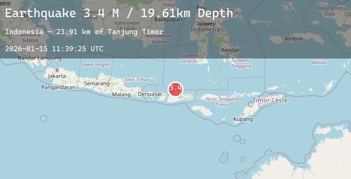
A 3.4 magnitude earthquake struck on Bali Sea, at Thu, 15 Jan 2026 11:39:24 GMT. Depth: 16.745684km. Reviewed by BMKG seismologists, this minor quake occurred at a magnitude type of M.
Magnitude
3.4
M
Source
BMKG
Intensity
-
Agency Reports
1 Sources| Source | Magnitude | Depth | Time |
|---|---|---|---|
| BMKGPrimary | 3.4 | 17 km | 4 hours ago |
Earthquake Details
AutomaticEvent IDbmg2026bamd
Tsunami PotentialNo
Magnitude TypeM
Nearest Places
- Tanjung Timor27.8 km
- Tanjung Sebaru28.7 km
- Sebaru29.2 km
- Desa Bajo Medang29.5 km
- Mandar30.6 km
Comments
Join the discussion about this event.
Latest Earthquakes
2.0Mag
NORTHERN CALIFORNIA
Time4 hours ago
Depth6.20 km
SourceNC (Automatic)
2.5Mag
NEAR COAST OF NICARAGUA
Time4 hours ago
Depth127.00 km
SourceINET (Automatic)
1.0Mag
13 km ESE of Mammoth Lakes, CA
Time4 hours ago
Depth4.70 km
SourceUSGS (Automatic)
2.6Mag
50 km ENE of Pedro Bay, Alaska
Time4 hours ago
Depth147.90 km
SourceUSGS (Automatic)
2.0Mag
86 km N of Karluk, Alaska
Time4 hours ago
Depth5.00 km
SourceUSGS (Automatic)
Nearby Earthquakes
3.9Mag
Sumbawa Region, Indonesia
Time7 hours ago
Depth20.06 km
SourceBMKG (Automatic)
2.2Mag
Sumbawa Region, Indonesia
Time13 hours ago
Depth10.82 km
SourceBMKG (Automatic)
2.0Mag
Sumbawa Region, Indonesia
Time15 hours ago
Depth21.43 km
SourceBMKG (Automatic)
2.1Mag
Sumbawa Region, Indonesia
Time22 hours ago
Depth10.00 km
SourceBMKG (Automatic)
2.0Mag
Sumbawa Region, Indonesia
Time23 hours ago
Depth10.00 km
SourceBMKG (Automatic)