Earthquake Talaud Islands, Indonesia
Sat, 24 Jan 2026 10:45:55 GMT
Time3 days ago
Location
4.9798, 125.5230
Depth
171.2 KM
Event Summary
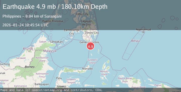
A 5.2 magnitude earthquake struck on Talaud Islands, Indonesia, at Sat, 24 Jan 2026 10:45:55 GMT. Depth: 171.239502km. Reviewed by BMKG seismologists, this moderate quake occurred at a magnitude type of M.
Magnitude
5.2
M
Source
BMKG
Intensity
-
Agency Reports
3 Sources| Source | Magnitude | Depth | Time |
|---|---|---|---|
| BMKGPrimary | 5.2 | 171 km | 3 days ago |
| USGS | 4.9 | 180 km | 3 days ago |
| NEIC | 4.9 | 180 km | 3 days ago |
Earthquake Details
AutomaticEvent IDbmg2026bqvw
Tsunami PotentialNo
Magnitude TypeM
Nearest Places
- Pulau Lungguhe26.2 km
- Pulau Laweang26.2 km
- Pulau Batubawaikang26.2 km
- Kecamatan Kepulauan Marore27.4 km
- Pulau Marore27.5 km
Comments
Join the discussion about this event.
Latest Earthquakes
2.9Mag
Sumba Region, Indonesia
Time5 minutes ago
Depth21.43 km
SourceBMKG (Automatic)
1.3Mag
WESTERN TURKEY
Time12 minutes ago
Depth12.50 km
SourceAFAD (Automatic)
2.4Mag
Java, Indonesia
Time13 minutes ago
Depth43.09 km
SourceBMKG (Automatic)
2.6Mag
ATACAMA, CHILE
Time15 minutes ago
Depth97.30 km
SourceCSN (Automatic)
3.8Mag
EASTERN TURKEY
Time17 minutes ago
Depth0.00 km
SourceKOERI (Automatic)
Nearby Earthquakes
4.6Mag
Mindanao, Philippines
Time3 days ago
Depth182.33 km
SourceBMKG (Automatic)
3.2Mag
KEPULAUAN SANGIHE, INDONESIA
Time1 day ago
Depth203.00 km
SourceBMKG (Automatic)
3.2Mag
Talaud Islands, Indonesia
Time3 days ago
Depth128.63 km
SourceBMKG (Automatic)
3.3Mag
MINDANAO, PHILIPPINES
Time1 day ago
Depth9.00 km
SourcePIVS (Automatic)
4.5Mag
Mindanao, Philippines
Time3 days ago
Depth14.02 km
SourceBMKG (Automatic)