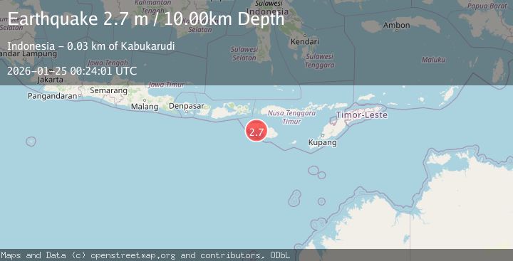
Earthquake Sumba Region, Indonesia
Sun, 25 Jan 2026 00:24:01 GMT
Time2 days ago
Location
-9.8248, 119.5716
Depth
10.0 KM
Event Summary
A 2.7 magnitude earthquake struck on Sumba Region, Indonesia, at Sun, 25 Jan 2026 00:24:01 GMT. Depth: 10km. Reviewed by BMKG seismologists, this minor quake occurred at a magnitude type of M.
Magnitude
2.7
M
Source
BMKG
Intensity
-
Agency Reports
1 Sources| Source | Magnitude | Depth | Time |
|---|---|---|---|
| BMKGPrimary | 2.7 | 10 km | 2 days ago |
Earthquake Details
AutomaticEvent IDbmg2026brww
Tsunami PotentialNo
Magnitude TypeM
Nearest Places
- Watu Apuladu5.6 km
- Tanjung Lisi5.8 km
- Tanjung Tapaj6.1 km
- Tanjung Taharu6.1 km
- Loko Laitarung6.2 km
Comments
Join the discussion about this event.
Latest Earthquakes
1.2Mag
12 km W of Stanton, Texas
Time19 hours ago
Depth4.52 km
SourceUSGS (Automatic)
2.0Mag
WESTERN TURKEY
Time19 hours ago
Depth7.60 km
SourceKOERI (Automatic)
4.4Mag
Sulawesi, Indonesia
Time19 hours ago
Depth5.00 km
SourceBMKG (Automatic)
1.8Mag
PYRENEES
Time20 hours ago
Depth1.40 km
SourceIGN (Automatic)
2.6Mag
Minahassa Peninsula, Sulawesi
Time20 hours ago
Depth118.00 km
SourceBMKG (Automatic)
Nearby Earthquakes
2.6Mag
Sumba Region, Indonesia
Time2 days ago
Depth57.11 km
SourceBMKG (Automatic)
2.3Mag
Sumba Region, Indonesia
Time22 hours ago
Depth63.48 km
SourceBMKG (Automatic)
2.4Mag
Sumba Region, Indonesia
Time2 days ago
Depth68.13 km
SourceBMKG (Automatic)
3.1Mag
Sumbawa Region, Indonesia
Time3 days ago
Depth10.00 km
SourceBMKG (Automatic)
2.4Mag
Sumbawa Region, Indonesia
Time1 day ago
Depth10.00 km
SourceBMKG (Automatic)