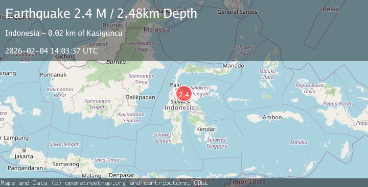
Earthquake Sulawesi, Indonesia
Wed, 04 Feb 2026 14:03:35 GMT
Time4 hours ago
Location
-1.2758, 120.6106
Depth
5.2 KM
Event Summary
A 2.1 magnitude earthquake struck on Sulawesi, Indonesia, at Wed, 04 Feb 2026 14:03:35 GMT. Depth: 5.223631km. Reviewed by BMKG seismologists, this minor quake occurred at a magnitude type of M.
Magnitude
2.1
M
Source
BMKG
Intensity
-
Agency Reports
1 Sources| Source | Magnitude | Depth | Time |
|---|---|---|---|
| BMKGPrimary | 2.1 | 5 km | 4 hours ago |
Earthquake Details
AutomaticEvent IDbmg2026cley
Tsunami PotentialNo
Magnitude TypeM
Nearest Places
- Muara Kameasi1.0 km
- Kuala Kameasi1.0 km
- Tanjung Towu1.1 km
- Kameasi1.7 km
- Towu1.8 km
Comments
Join the discussion about this event.
Latest Earthquakes
1.1Mag
8 km NW of The Geysers, CA
Time4 hours ago
Depth1.76 km
SourceUSGS (Automatic)
2.0Mag
56 km ESE of Lovelock, Nevada
Time4 hours ago
Depth10.45 km
SourceUSGS (Automatic)
2.8Mag
12 km NNE of Cantwell, Alaska
Time4 hours ago
Depth0.00 km
SourceUSGS (Automatic)
2.8Mag
Flores Region, Indonesia
Time4 hours ago
Depth96.66 km
SourceBMKG (Automatic)
2.1Mag
Sulawesi, Indonesia
Time4 hours ago
Depth10.03 km
SourceBMKG (Automatic)
Nearby Earthquakes
2.6Mag
Sulawesi, Indonesia
Time1 week ago
Depth6.81 km
SourceBMKG (Automatic)
2.1Mag
Sulawesi, Indonesia
Time1 week ago
Depth7.06 km
SourceBMKG (Automatic)
2.5Mag
Sulawesi, Indonesia
Time5 days ago
Depth3.11 km
SourceBMKG (Automatic)
2.9Mag
Sulawesi, Indonesia
Time1 week ago
Depth4.42 km
SourceBMKG (Automatic)
2.6Mag
Sulawesi, Indonesia
Time1 week ago
Depth3.28 km
SourceBMKG (Automatic)