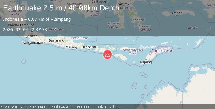
Earthquake Sumbawa Region, Indonesia
Wed, 04 Feb 2026 22:37:32 GMT
Time3 hours ago
Location
-9.4638, 117.9662
Depth
23.6 KM
Event Summary
A 2.3 magnitude earthquake struck on Sumbawa Region, Indonesia, at Wed, 04 Feb 2026 22:37:32 GMT. Depth: 23.578096km. Reviewed by BMKG seismologists, this minor quake occurred at a magnitude type of M.
Magnitude
2.3
M
Source
BMKG
Intensity
-
Agency Reports
1 Sources| Source | Magnitude | Depth | Time |
|---|---|---|---|
| BMKGPrimary | 2.3 | 24 km | 3 hours ago |
Earthquake Details
AutomaticEvent IDbmg2026clvx
Tsunami PotentialNo
Magnitude TypeM
Nearest Places
- Tanjung Mata58.2 km
- Kokar Aipanam59.5 km
- Teluk Jongrusak59.6 km
- Brang Aimumit59.7 km
- Teluk Baru59.8 km
Comments
Join the discussion about this event.
Latest Earthquakes
1.9Mag
33 km W of Empire, Nevada
Time3 hours ago
Depth4.76 km
SourceUSGS (Automatic)
2.1Mag
NEAR THE COAST OF WESTERN TURKEY
Time4 hours ago
Depth6.30 km
SourceKOERI (Automatic)
3.2Mag
SOUTHWEST OF SUMATRA, INDONESIA
Time4 hours ago
Depth61.00 km
SourceBMKG (Automatic)
3.2Mag
Southern Sumatra, Indonesia
Time4 hours ago
Depth25.26 km
SourceBMKG (Automatic)
4.0Mag
ALBANIA
Time4 hours ago
Depth9.70 km
SourceNOA (Automatic)
Nearby Earthquakes
3.1Mag
Sumbawa Region, Indonesia
Time3 days ago
Depth20.98 km
SourceBMKG (Automatic)
3.2Mag
Sumbawa Region, Indonesia
Time4 days ago
Depth29.00 km
SourceBMKG (Automatic)
2.4Mag
Sumbawa Region, Indonesia
Time1 week ago
Depth24.43 km
SourceBMKG (Automatic)
2.2Mag
Sumbawa Region, Indonesia
Time1 day ago
Depth24.03 km
SourceBMKG (Automatic)
3.0Mag
Sumbawa Region, Indonesia
Time1 week ago
Depth51.24 km
SourceBMKG (Automatic)