Earthquake Sunda Strait, Indonesia
Thu, 12 Feb 2026 20:50:18 GMT
Time6 days ago
Location
-6.3255, 104.3970
Depth
21.2 KM
Event Summary
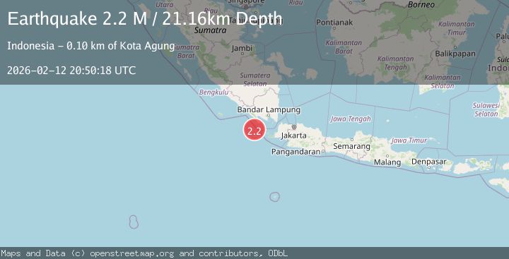
A 2.2 magnitude earthquake struck on Sunda Strait, Indonesia, at Thu, 12 Feb 2026 20:50:18 GMT. Depth: 21.162416km. Reviewed by BMKG seismologists, this minor quake occurred at a magnitude type of M.
Magnitude
2.2
M
Source
BMKG
Intensity
-
Agency Reports
1 Sources| Source | Magnitude | Depth | Time |
|---|---|---|---|
| BMKGPrimary | 2.2 | 21 km | 6 days ago |
Earthquake Details
ManualEvent IDbmg2026daij
Tsunami PotentialNo
Magnitude TypeM
Nearest Places
- Tanjung Cuku Balimbing15.9 km
- Ujung Saleman47.3 km
- Pulau Betuah48.5 km
- Wai Saliman48.5 km
- Wai Kejadina48.8 km
Comments
Join the discussion about this event.
Latest Earthquakes
1.4Mag
EASTERN TURKEY
Time7 minutes ago
Depth6.80 km
SourceAFAD (Automatic)
1.7Mag
northern Alaska
Time8 minutes ago
Depth4.64 km
SourceVYT (Automatic)
1.2Mag
5 km WNW of The Geysers, CA
Time13 minutes ago
Depth3.19 km
SourceUSGS (Automatic)
3.4Mag
Sulawesi, Indonesia
Time16 minutes ago
Depth27.95 km
SourceVYT (Automatic)
1.6Mag
Central Alaska
Time18 minutes ago
Depth18.07 km
SourceVYT (Automatic)
Nearby Earthquakes
2.7Mag
Sunda Strait, Indonesia
Time2 weeks ago
Depth11.88 km
SourceBMKG (Automatic)
4.0Mag
SUNDA STRAIT, INDONESIA
Time2 years ago
Depth11.00 km
SourceBMKG (Automatic)
5.6Mag
SUNDA STRAIT, INDONESIA
Time17 years ago
Depth54.00 km
SourceEMSC (Automatic)
3.0Mag
SUNDA STRAIT, INDONESIA
Time1 year ago
Depth11.00 km
SourceBMKG (Automatic)
3.3Mag
Sunda Strait, Indonesia
Time2 weeks ago
Depth12.92 km
SourceBMKG (Automatic)