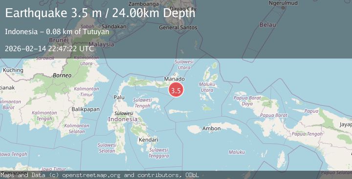
Earthquake Minahassa Peninsula, Sulawesi
Sat, 14 Feb 2026 22:47:22 GMT
Time1 week ago
Location
0.1402, 124.9901
Depth
23.5 KM
Event Summary
A 3.5 magnitude earthquake struck on Minahassa Peninsula, Sulawesi, at Sat, 14 Feb 2026 22:47:22 GMT. Depth: 23.503124km. Reviewed by BMKG seismologists, this minor quake occurred at a magnitude type of M.
Magnitude
3.5
M
Source
BMKG
Intensity
-
Agency Reports
1 Sources| Source | Magnitude | Depth | Time |
|---|---|---|---|
| BMKGPrimary | 3.5 | 24 km | 1 week ago |
Earthquake Details
ManualEvent IDbmg2026dedg
Tsunami PotentialNo
Magnitude TypeM
Nearest Places
- 63.5 km
- 64.7 km
- 65.0 km
- 65.7 km
- 66.5 km
Comments
Join the discussion about this event.
Latest Earthquakes
1.2Mag
Tarapaca, Chile
Time2 minutes ago
Depth0.00 km
SourceVYT (Automatic)
2.1Mag
Fox Islands, Aleutian Islands, Alaska
Time4 minutes ago
Depth0.98 km
SourceVYT (Automatic)
0.7Mag
2 km NNW of The Geysers, CA
Time6 minutes ago
Depth2.94 km
SourceUSGS (Automatic)
1.7Mag
52 km SSE of Denali National Park, Alaska
Time7 minutes ago
Depth5.00 km
SourceUSGS (Automatic)
2.8Mag
New Mexico
Time9 minutes ago
Depth0.00 km
SourceVYT (Automatic)
Nearby Earthquakes
5.6Mag
MOLUCCA SEA
Time15 years ago
Depth60.00 km
SourceEMSC (Automatic)
5.0Mag
MINAHASA, SULAWESI, INDONESIA
Time0 years ago
Depth10.00 km
SourceEMSC (Automatic)
3.0Mag
MOLUCCA SEA
Time9 months ago
Depth20.00 km
SourceBMKG (Automatic)
3.3Mag
Molucca Sea
Time3 hours ago
Depth0.00 km
SourceVYT (Automatic)
2.9Mag
MINAHASA, SULAWESI, INDONESIA
Time1 month ago
Depth18.00 km
SourceBMKG (Automatic)