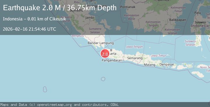
Earthquake Sunda Strait, Indonesia
Mon, 16 Feb 2026 21:54:46 GMT
Time1 day ago
Location
-6.6873, 105.9389
Depth
36.7 KM
Event Summary
A 2.0 magnitude earthquake struck on Sunda Strait, Indonesia, at Mon, 16 Feb 2026 21:54:46 GMT. Depth: 36.749695km. Reviewed by BMKG seismologists, this minor quake occurred at a magnitude type of M.
Magnitude
2.0
M
Source
BMKG
Intensity
-
Agency Reports
1 Sources| Source | Magnitude | Depth | Time |
|---|---|---|---|
| BMKGPrimary | 2.0 | 37 km | 1 day ago |
Earthquake Details
ManualEvent IDbmg2026dhsn
Tsunami PotentialNo
Magnitude TypeM
Nearest Places
- Cilaki1.4 km
- Babakanlengkong1.5 km
- Pasirbuntu1.6 km
- Cipadung1.8 km
- Desa Karangpamindangan1.8 km
Comments
Join the discussion about this event.
Latest Earthquakes
2.4Mag
Finland
Time1 minute ago
Depth301.88 km
SourceVYT (Automatic)
1.2Mag
Alaska Peninsula
Time2 minutes ago
Depth0.12 km
SourceVYT (Automatic)
3.1Mag
DODECANESE IS.-TURKEY BORDER REG
Time8 minutes ago
Depth4.10 km
SourceKOERI (Automatic)
2.6Mag
NEAR COAST OF NICARAGUA
Time13 minutes ago
Depth38.00 km
SourceINET (Automatic)
1.4Mag
Central Alaska
Time16 minutes ago
Depth110.35 km
SourceVYT (Automatic)
Nearby Earthquakes
3.9Mag
Sunda Strait, Indonesia
Time22 hours ago
Depth97.11 km
SourceBMKG
3.0Mag
JAVA, INDONESIA
Time2 years ago
Depth151.00 km
SourceDJA (Automatic)
3.0Mag
Sunda Strait, Indonesia
Time4 days ago
Depth103.36 km
SourceBMKG
3.0Mag
SUNDA STRAIT, INDONESIA
Time1 year ago
Depth96.00 km
SourceBMKG (Automatic)
3.0Mag
SUNDA STRAIT, INDONESIA
Time3 years ago
Depth122.00 km
SourceDJA (Automatic)