Earthquake Timor Region
Thu, 19 Feb 2026 03:05:42 GMT
Time1 hour ago
Location
-9.0610, 123.8856
Depth
54.3 KM
Event Summary
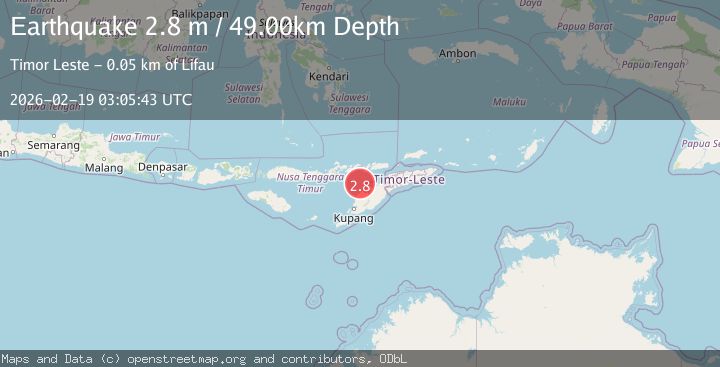
A 2.8 magnitude earthquake struck on Timor Region, at Thu, 19 Feb 2026 03:05:42 GMT. Depth: 54.289467km. Reviewed by BMKG seismologists, this minor quake occurred at a magnitude type of M.
Magnitude
2.8
M
Source
BMKG
Intensity
-
Agency Reports
1 Sources| Source | Magnitude | Depth | Time |
|---|---|---|---|
| BMKGPrimary | 2.8 | 54 km | 1 hour ago |
Earthquake Details
ManualEvent IDbmg2026dltu
Tsunami PotentialNo
Magnitude TypeM
Nearest Places
- Pulau Batek25.3 km
- Tanjung Temekuna33.5 km
- Tanjung Nasikonis33.9 km
- Tobu33.9 km
- Tubufatuknutu34.1 km
Comments
Join the discussion about this event.
Latest Earthquakes
3.4Mag
Rat Islands, Aleutian Islands, Alaska
Time1 hour ago
Depth112.18 km
SourceVYT (Automatic)
3.2Mag
Southern Alaska
Time1 hour ago
Depth76.29 km
SourceVYT (Automatic)
3.8Mag
Nicaragua
Time1 hour ago
Depth342.53 km
SourceVYT (Automatic)
1.5Mag
Tarapaca, Chile
Time1 hour ago
Depth1.95 km
SourceVYT (Automatic)
3.8Mag
San Juan, Argentina
Time1 hour ago
Depth173.34 km
SourceVYT (Automatic)
Nearby Earthquakes
3.0Mag
TIMOR REGION, INDONESIA
Time3 years ago
Depth85.00 km
SourceDJA (Automatic)
5.5Mag
TIMOR REGION, INDONESIA
Time2 years ago
Depth94.00 km
SourceEMSC (Automatic)
3.0Mag
TIMOR REGION, INDONESIA
Time1 year ago
Depth41.00 km
SourceBMKG (Automatic)
3.0Mag
TIMOR REGION, INDONESIA
Time3 months ago
Depth49.00 km
SourceBMKG (Automatic)
2.8Mag
TIMOR REGION, INDONESIA
Time3 weeks ago
Depth64.00 km
SourceBMKG (Automatic)