Earthquake Northern Sumatra, Indonesia
Mon, 23 Feb 2026 08:35:34 GMT
Time1 hour ago
Location
1.7871, 98.7730
Depth
82.5 KM
Event Summary
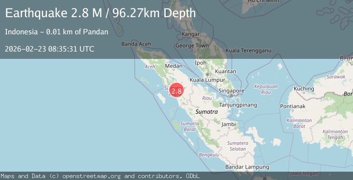
A 2.7 magnitude earthquake struck on Northern Sumatra, Indonesia, at Mon, 23 Feb 2026 08:35:34 GMT. Depth: 82.470383km. Reviewed by BMKG seismologists, this minor quake occurred at a magnitude type of M.
Magnitude
2.7
M
Source
BMKG
Intensity
-
Agency Reports
1 Sources| Source | Magnitude | Depth | Time |
|---|---|---|---|
| BMKGPrimary | 2.7 | 82 km | 1 hour ago |
Earthquake Details
ManualEvent IDbmg2026dtmr
Tsunami PotentialNo
Magnitude TypeM
Nearest Places
- 0.4 km
- 0.7 km
- 0.8 km
- 0.9 km
- 1.0 km
Comments
Join the discussion about this event.
Latest Earthquakes
1.5Mag
28 km ENE of Skwentna, Alaska
Time1 hour ago
Depth63.30 km
SourceUSGS (Automatic)
1.9Mag
Kenai Peninsula, Alaska
Time1 hour ago
Depth11.60 km
SourceVYT (Automatic)
2.7Mag
Halmahera, Indonesia
Time1 hour ago
Depth49.32 km
SourceBMKG
2.3Mag
Antofagasta, Chile
Time1 hour ago
Depth0.00 km
SourceVYT (Automatic)
3.3Mag
Minahasa, Sulawesi, Indonesia
Time1 hour ago
Depth0.00 km
SourceVYT (Automatic)
Nearby Earthquakes
5.1Mag
NORTHERN SUMATRA, INDONESIA
Time15 years ago
Depth125.00 km
SourceEMSC (Automatic)
4.0Mag
NORTHERN SUMATRA, INDONESIA
Time5 years ago
Depth113.00 km
SourceDJA (Automatic)
5.0Mag
NORTHERN SUMATRA, INDONESIA
Time20 years ago
Depth33.00 km
SourceEMSC (Automatic)
5.8Mag
NORTHERN SUMATRA, INDONESIA
Time17 years ago
Depth10.00 km
SourceEMSC (Automatic)
5.0Mag
NORTHERN SUMATRA, INDONESIA
Time7 years ago
Depth126.00 km
SourceEMSC (Automatic)