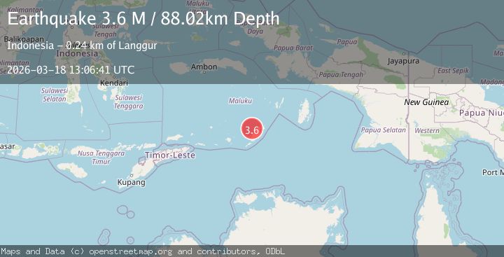
Earthquake Tanimbar Islands Region, Indonesia
Wed, 18 Mar 2026 13:06:41 GMT
Time2 weeks ago
Location
-7.2001, 131.2177
Depth
88.0 KM
Event Summary
A 3.6 magnitude earthquake struck on Tanimbar Islands Region, Indonesia, at Wed, 18 Mar 2026 13:06:41 GMT. Depth: 88.016106km. Reviewed by BMKG seismologists, this minor quake occurred at a magnitude type of M.
Magnitude
3.6
M
Source
BMKG
Intensity
-
Agency Reports
1 Sources| Source | Magnitude | Depth | Time |
|---|---|---|---|
| BMKGPrimary | 3.6 | 88 km | 2 weeks ago |
Earthquake Details
ManualEvent IDbmg2026fjwe
QualityS
Tsunami PotentialNo
Magnitude TypeM
Last Update2 weeks ago
Felt Reports0
Did you feel this earthquake? Report it to help others.
No reports yet
Be the first to report this earthquake!
Latest Earthquakes
Loading...
Nearby Earthquakes
4.1Mag
Kepulauan Tanimbar, Indonesia
Time21 hours ago
Depth675.17 km
SourceVYT (Automatic)
3.5Mag
Kepulauan Tanimbar, Indonesia
Time22 hours ago
Depth135.01 km
SourceVYT (Automatic)
4.5Mag
Kepulauan Tanimbar, Indonesia
Time1 day ago
Depth150.02 km
SourceVYT (Automatic)
2.6Mag
Kepulauan Tanimbar, Indonesia
Time1 week ago
Depth153.93 km
SourceVYT (Automatic)
3.5Mag
Kepulauan Tanimbar, Indonesia
Time1 week ago
Depth124.27 km
SourceVYT (Automatic)