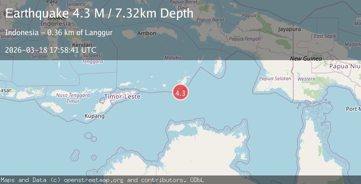
Earthquake Tanimbar Islands Region, Indonesia
Wed, 18 Mar 2026 17:58:41 GMT
Time3 weeks ago
Location
-8.4542, 131.1587
Depth
7.3 KM
Event Summary
A 4.3 magnitude earthquake struck on Tanimbar Islands Region, Indonesia, at Wed, 18 Mar 2026 17:58:41 GMT. Depth: 7.316957km. Reviewed by BMKG seismologists, this light quake occurred at a magnitude type of M.
Magnitude
4.3
M
Source
BMKG
Intensity
-
Agency Reports
1 Sources| Source | Magnitude | Depth | Time |
|---|---|---|---|
| BMKGPrimary | 4.3 | 7 km | 3 weeks ago |
Earthquake Details
ManualEvent IDbmg2026fkfv
QualityS
Tsunami PotentialNo
Magnitude TypeM
Last Update3 weeks ago
Felt Reports0
Did you feel this earthquake? Report it to help others.
No reports yet
Be the first to report this earthquake!
Latest Earthquakes
Loading...
Nearby Earthquakes
3.8Mag
Timor Sea
Time2 days ago
Depth739.14 km
SourceVYT (Automatic)
4.4Mag
Kepulauan Tanimbar, Indonesia
Time6 days ago
Depth0.00 km
SourceVYT (Automatic)
4.4Mag
Kepulauan Tanimbar, Indonesia
Time2 weeks ago
Depth88.50 km
SourceVYT (Automatic)
2.8Mag
Kepulauan Tanimbar, Indonesia
Time1 month ago
Depth652.71 km
SourceVYT (Automatic)
3.0Mag
KEP. TANIMBAR REGION, INDONESIA
Time0 years ago
Depth189.00 km
SourceBMKG (Automatic)