Earthquake Northern Molucca Sea
Tue, 12 May 2026 18:10:24 GMT
Time3 days ago
Location
2.9720, 127.8803
Depth
48.0 KM
Event Summary
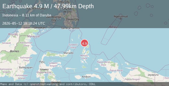
A 4.9 magnitude earthquake struck on Northern Molucca Sea, at Tue, 12 May 2026 18:10:24 GMT. Depth: 47.994804km. Reviewed by BMKG seismologists, this light quake occurred at a magnitude type of M.
Magnitude
4.9
M
Source
BMKG
Intensity
II
Agency Reports
4 Sources| Source | Magnitude | Depth | Time |
|---|---|---|---|
| BMKGPrimary | 4.9 | 48 km | 3 days ago |
| VYT | 4.8 | 86 km | 3 days ago |
| GSRAS | 4.8 | 100 km | 3 days ago |
| EMSC | 4.7 | 90 km | 3 days ago |
Earthquake Details
ManualEvent IDbmg2026jgsw
QualityS
Tsunami PotentialNo
Magnitude TypeM
Last Update2 days ago
Used Stations60
Total Stations66
Nearest Places
Possibly felt by: 26.3K
- IIDaruba112.3 km
- IITobelo139.0 km34.1K people
- IIMangaran156.8 km
- 167.8 km
- IILirung169.7 km
- 179.7 km
- IBeo184.5 km
- 207.8 km
- 208.5 km
- 208.6 km
- 216.9 km
- 248.7 km205K people
- 250.0 km
- 250.9 km
- 251.0 km36.2K people
- 254.0 km
- IMaba256.7 km12.6K people
- 257.7 km
- 258.3 km
- IBuli258.3 km
- IKuma264.6 km
- 268.4 km
- 269.0 km
- 270.7 km
- 276.2 km
- IUlu277.8 km
- 280.9 km
- 286.4 km
- 286.6 km
- IWeda293.8 km
- 294.4 km
Felt Reports0
Did you feel this earthquake? Report it to help others.
No reports yet
Be the first to report this earthquake!
Latest Earthquakes
Loading...
Nearby Earthquakes
3.6Mag
North of Halmahera, Indonesia
Time16 hours ago
Depth57.64 km
SourceBMKG
3.0Mag
HALMAHERA, INDONESIA
Time1 day ago
Depth125.00 km
SourceBMKG (Automatic)
2.9Mag
Halmahera, Indonesia
Time3 days ago
Depth172.41 km
SourceBMKG
4.2Mag
Talaud Islands, Indonesia
Time4 days ago
Depth25.11 km
SourceBMKG
3.0Mag
Halmahera, Indonesia
Time6 days ago
Depth144.72 km
SourceBMKG