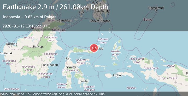
Earthquake MINAHASA, SULAWESI, INDONESIA
Mon, 12 Jan 2026 13:16:22 GMT
Time1 month ago
Location
1.1900, 124.2300
Depth
261.0 KM
Event Summary
A 2.9 magnitude earthquake struck on MINAHASA, SULAWESI, INDONESIA, at Mon, 12 Jan 2026 13:16:22 GMT. Depth: 261km. Reviewed by BMKG seismologists, this minor quake occurred at a magnitude type of m.
Magnitude
2.9
m
Source
BMKG
Intensity
-
Agency Reports
1 Sources| Source | Magnitude | Depth | Time |
|---|---|---|---|
| BMKGPrimary | 2.9 | 261 km | 1 month ago |
Earthquake Details
AutomaticEvent IDemsc_BMKG_20260112_0000192
Tsunami PotentialNo
Magnitude Typem
Nearest Places
- Tanjung Lempangi13.2 km
- Teluk Lampangi13.4 km
- Royongan Pakin14.2 km
- Lesuk Pakin14.6 km
- Royongan Boyong14.7 km
Comments
Join the discussion about this event.
Latest Earthquakes
1.3Mag
29 km W of Garden City, Texas
Time5 minutes ago
Depth3.35 km
SourceUSGS (Automatic)
2.1Mag
6 km NE of Beaverdam, Nevada
Time7 minutes ago
Depth11.45 km
SourceUSGS (Automatic)
3.4Mag
NORTH ISLAND OF NEW ZEALAND
Time14 minutes ago
Depth146.90 km
SourceGNS (Automatic)
2.6Mag
WESTERN TURKEY
Time20 minutes ago
Depth7.30 km
SourceKOERI (Automatic)
3.7Mag
YUNNAN, CHINA
Time21 minutes ago
Depth10.00 km
SourceTSB (Automatic)
Nearby Earthquakes
5.6Mag
MINAHASA, SULAWESI, INDONESIA
Time6 years ago
Depth258.00 km
SourceEMSC (Automatic)
4.0Mag
MINAHASA, SULAWESI, INDONESIA
Time4 years ago
Depth250.00 km
SourceDJA (Automatic)
4.0Mag
MINAHASA, SULAWESI, INDONESIA
Time5 years ago
Depth10.00 km
SourceDJA (Automatic)
2.7Mag
MINAHASA, SULAWESI, INDONESIA
Time1 week ago
Depth61.00 km
SourceBMKG (Automatic)
4.0Mag
MINAHASA, SULAWESI, INDONESIA
Time1 year ago
Depth258.00 km
SourceBMKG (Automatic)