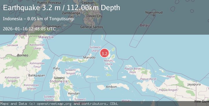
Earthquake HALMAHERA, INDONESIA
Fri, 16 Jan 2026 12:48:05 GMT
Time1 month ago
Location
1.7800, 127.1600
Depth
112.0 KM
Event Summary
A 3.2 magnitude earthquake struck on HALMAHERA, INDONESIA, at Fri, 16 Jan 2026 12:48:05 GMT. Depth: 112km. Reviewed by BMKG seismologists, this minor quake occurred at a magnitude type of m.
Magnitude
3.2
m
Source
BMKG
Intensity
-
Agency Reports
1 Sources| Source | Magnitude | Depth | Time |
|---|---|---|---|
| BMKGPrimary | 3.2 | 112 km | 1 month ago |
Earthquake Details
AutomaticEvent IDemsc_BMKG_20260116_0000232
Tsunami PotentialNo
Magnitude Typem
Nearest Places
- Nyi30.5 km
- Nusa Sidanga38.3 km
- Nusa Nyaolaka38.5 km
- Nusa Sosota39.1 km
- Kepulauan Loloda Selatan39.8 km
Comments
Join the discussion about this event.
Latest Earthquakes
1.7Mag
western Texas
Time6 minutes ago
Depth3.42 km
SourceVYT (Automatic)
3.8Mag
Seram, Indonesia
Time8 minutes ago
Depth0.00 km
SourceVYT (Automatic)
1.6Mag
54 km WNW of Toyah, Texas
Time13 minutes ago
Depth0.00 km
SourceUSGS (Automatic)
2.2Mag
West Papua Region, Indonesia
Time15 minutes ago
Depth26.69 km
SourceBMKG
1.2Mag
WESTERN TURKEY
Time15 minutes ago
Depth7.00 km
SourceAFAD (Automatic)
Nearby Earthquakes
4.0Mag
HALMAHERA, INDONESIA
Time1 year ago
Depth94.00 km
SourceBMKG (Automatic)
5.5Mag
HALMAHERA, INDONESIA
Time3 years ago
Depth60.00 km
SourceEMSC (Automatic)
3.0Mag
HALMAHERA, INDONESIA
Time2 years ago
Depth95.00 km
SourceDJA (Automatic)
4.0Mag
HALMAHERA, INDONESIA
Time1 year ago
Depth102.00 km
SourceBMKG (Automatic)
3.0Mag
HALMAHERA, INDONESIA
Time10 months ago
Depth15.00 km
SourceBMKG (Automatic)