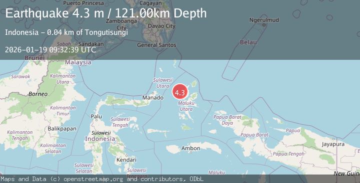
Earthquake HALMAHERA, INDONESIA
Mon, 19 Jan 2026 09:32:39 GMT
Time1 month ago
Location
1.6300, 127.2400
Depth
121.0 KM
Event Summary
A 4.3 magnitude earthquake struck on HALMAHERA, INDONESIA, at Mon, 19 Jan 2026 09:32:39 GMT. Depth: 121km. Reviewed by BMKG seismologists, this light quake occurred at a magnitude type of m.
Magnitude
4.3
m
Source
BMKG
Intensity
-
Agency Reports
1 Sources| Source | Magnitude | Depth | Time |
|---|---|---|---|
| BMKGPrimary | 4.3 | 121 km | 1 month ago |
Earthquake Details
AutomaticEvent IDemsc_BMKG_20260119_0000105
Tsunami PotentialNo
Magnitude Typem
Nearest Places
- Nyi21.5 km
- Nusa Nyaolaka27.1 km
- Nusa Sidanga27.5 km
- Nusa Sosota28.1 km
- Kepulauan Loloda Selatan29.2 km
Comments
Join the discussion about this event.
Latest Earthquakes
2.6Mag
Minahasa, Sulawesi, Indonesia
Time2 minutes ago
Depth3.17 km
SourceVYT (Automatic)
2.6Mag
Antofagasta, Chile
Time2 minutes ago
Depth125.12 km
SourceVYT (Automatic)
0.8Mag
7 km NW of The Geysers, CA
Time6 minutes ago
Depth1.32 km
SourceUSGS (Automatic)
2.7Mag
San Juan, Argentina
Time11 minutes ago
Depth363.53 km
SourceVYT (Automatic)
2.5Mag
Java, Indonesia
Time11 minutes ago
Depth115.43 km
SourceBMKG
Nearby Earthquakes
5.3Mag
HALMAHERA, INDONESIA
Time15 years ago
Depth26.00 km
SourceEMSC (Automatic)
5.3Mag
HALMAHERA, INDONESIA
Time17 years ago
Depth108.00 km
SourceEMSC (Automatic)
5.1Mag
HALMAHERA, INDONESIA
Time2 months ago
Depth121.90 km
SourceEMSC (Automatic)
2.5Mag
Halmahera, Indonesia
Time4 days ago
Depth124.83 km
SourceBMKG
3.1Mag
Halmahera, Indonesia
Time2 weeks ago
Depth122.31 km
SourceBMKG (Automatic)