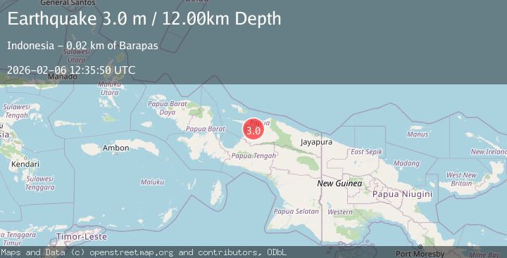
Earthquake NEAR N COAST OF PAPUA, INDONESIA
Fri, 06 Feb 2026 12:35:50 GMT
Time1 week ago
Location
-2.1700, 136.8000
Depth
12.0 KM
Event Summary
A 3.0 magnitude earthquake struck on NEAR N COAST OF PAPUA, INDONESIA, at Fri, 06 Feb 2026 12:35:50 GMT. Depth: 12km. Reviewed by BMKG seismologists, this minor quake occurred at a magnitude type of m.
Magnitude
3.0
m
Source
BMKG
Intensity
-
Agency Reports
1 Sources| Source | Magnitude | Depth | Time |
|---|---|---|---|
| BMKGPrimary | 3.0 | 12 km | 1 week ago |
Earthquake Details
AutomaticEvent IDemsc_BMKG_20260206_0000209
Tsunami PotentialNo
Magnitude Typem
Nearest Places
- Banderi Waidou2.4 km
- Tanjung Nadubuai3.3 km
- Sungai Nadubuai4.1 km
- Nadubuai5.5 km
- Puso7.4 km
Comments
Join the discussion about this event.
Latest Earthquakes
3.2Mag
Antofagasta, Chile
Time11 hours ago
Depth124.27 km
SourceVYT (Automatic)
1.7Mag
Kenai Peninsula, Alaska
Time11 hours ago
Depth28.44 km
SourceVYT (Automatic)
1.7Mag
Tarapaca, Chile
Time11 hours ago
Depth6.47 km
SourceVYT (Automatic)
1.9Mag
Central Alaska
Time11 hours ago
Depth81.18 km
SourceVYT (Automatic)
1.2Mag
21 km ENE of Little Lake, CA
Time11 hours ago
Depth0.90 km
SourceUSGS (Automatic)
Nearby Earthquakes
5.0Mag
NEAR N COAST OF PAPUA, INDONESIA
Time14 years ago
Depth40.00 km
SourceEMSC (Automatic)
5.0Mag
NEAR N COAST OF PAPUA, INDONESIA
Time15 years ago
Depth10.00 km
SourceEMSC (Automatic)
6.4Mag
NEAR N COAST OF PAPUA, INDONESIA
Time14 years ago
Depth40.00 km
SourceEMSC (Automatic)
4.0Mag
NEAR N COAST OF PAPUA, INDONESIA
Time1 year ago
Depth20.00 km
SourceBMKG (Automatic)
5.4Mag
NEAR N COAST OF PAPUA, INDONESIA
Time14 years ago
Depth10.00 km
SourceEMSC (Automatic)