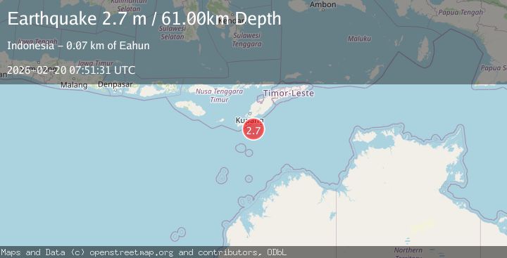
Earthquake SOUTH OF TIMOR
Fri, 20 Feb 2026 07:51:31 GMT
Time1 day ago
Location
-11.0500, 123.8800
Depth
61.0 KM
Event Summary
A 2.7 magnitude earthquake struck on SOUTH OF TIMOR, at Fri, 20 Feb 2026 07:51:31 GMT. Depth: 61km. Reviewed by BMKG seismologists, this minor quake occurred at a magnitude type of m.
Magnitude
2.7
m

Source
BMKG
Intensity
-
Agency Reports
1 Sources| Source | Magnitude | Depth | Time |
|---|---|---|---|
| BMKGPrimary | 2.7 | 61 km | 1 day ago |
Earthquake Details
AutomaticEvent IDemsc_BMKG_20260220_0000105
Tsunami PotentialNo
Magnitude Typem
Nearest Places
- 65.3 km
- 65.3 km
- 66.0 km
- 66.2 km
- 66.3 km
Comments
Join the discussion about this event.
Latest Earthquakes
2.8Mag
Coquimbo, Chile
Time2 minutes ago
Depth0.12 km
SourceVYT (Automatic)
1.1Mag
Central Alaska
Time7 minutes ago
Depth53.34 km
SourceVYT (Automatic)
2.4Mag
Halmahera, Indonesia
Time10 minutes ago
Depth5.24 km
SourceBMKG
1.3Mag
WESTERN TURKEY
Time15 minutes ago
Depth6.80 km
SourceAFAD (Automatic)
1.1Mag
7 km NW of The Geysers, CA
Time18 minutes ago
Depth1.89 km
SourceUSGS (Automatic)
Nearby Earthquakes
3.3Mag
TIMOR REGION, INDONESIA
Time1 month ago
Depth117.00 km
SourceBMKG (Automatic)
3.1Mag
TIMOR REGION, INDONESIA
Time1 month ago
Depth14.00 km
SourceBMKG (Automatic)
4.1Mag
Timor region, Indonesia
Time1 week ago
Depth0.00 km
SourceVYT (Automatic)
3.2Mag
SOUTH OF TIMOR
Time1 month ago
Depth10.00 km
SourceBMKG (Automatic)
3.0Mag
TIMOR REGION, INDONESIA
Time3 months ago
Depth92.00 km
SourceBMKG (Automatic)