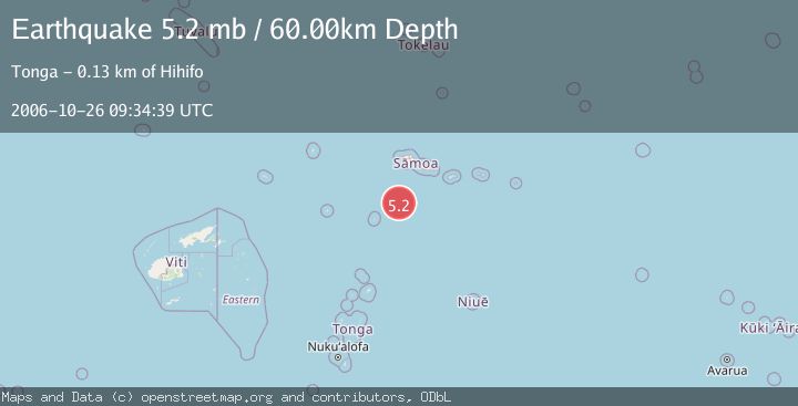
Earthquake SAMOA ISLANDS REGION
Thu, 26 Oct 2006 09:34:39 GMT
Time19 years ago
Location
-15.2900, -172.7700
Depth
60.0 KM
Event Summary
A 5.2 magnitude earthquake struck on SAMOA ISLANDS REGION, at Thu, 26 Oct 2006 09:34:39 GMT. Depth: 60km. Reviewed by EMSC seismologists, this moderate quake occurred at a magnitude type of mb.
Magnitude
5.2
mb
Source
EMSC
Intensity
-
Agency Reports
1 Sources| Source | Magnitude | Depth | Time |
|---|---|---|---|
| EMSCPrimary | 5.2 | 60 km | 19 years ago |
Earthquake Details
AutomaticEvent IDemsc_EMSC_20061026_0000038
Tsunami PotentialNo
Magnitude Typemb
Nearest Places
- 95.9 km
- 121.9 km
- 125.4 km
- 126.5 km
- 126.7 km
Comments
Join the discussion about this event.
Latest Earthquakes
2.7Mag
Halmahera, Indonesia
Time7 minutes ago
Depth49.32 km
SourceBMKG
2.3Mag
Antofagasta, Chile
Time10 minutes ago
Depth0.00 km
SourceVYT (Automatic)
3.3Mag
Minahasa, Sulawesi, Indonesia
Time14 minutes ago
Depth0.00 km
SourceVYT (Automatic)
3.0Mag
northern Colombia
Time15 minutes ago
Depth175.66 km
SourceVYT (Automatic)
2.1Mag
Greater Los Angeles area, California
Time15 minutes ago
Depth0.00 km
SourceVYT (Automatic)
Nearby Earthquakes
5.1Mag
SAMOA ISLANDS REGION
Time6 years ago
Depth10.00 km
SourceEMSC (Automatic)
5.5Mag
SAMOA ISLANDS REGION
Time17 years ago
Depth10.00 km
SourceEMSC (Automatic)
5.5Mag
SAMOA ISLANDS REGION
Time5 years ago
Depth10.00 km
SourceEMSC (Automatic)
5.1Mag
SAMOA ISLANDS REGION
Time7 years ago
Depth10.00 km
SourceEMSC (Automatic)
5.1Mag
SAMOA ISLANDS REGION
Time3 years ago
Depth10.00 km
SourceEMSC (Automatic)