Earthquake SOUTHERN SUMATRA, INDONESIA
Wed, 12 Sep 2007 22:02:22 GMT
Time18 years ago
Location
-4.3800, 101.2300
Depth
10.0 KM
Event Summary
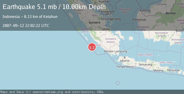
A 5.1 magnitude earthquake struck on SOUTHERN SUMATRA, INDONESIA, at Wed, 12 Sep 2007 22:02:22 GMT. Depth: 10km. Reviewed by EMSC seismologists, this moderate quake occurred at a magnitude type of mb.
Magnitude
5.1
mb
Source
EMSC
Intensity
-
Agency Reports
1 Sources| Source | Magnitude | Depth | Time |
|---|---|---|---|
| EMSCPrimary | 5.1 | 10 km | 18 years ago |
Earthquake Details
AutomaticEvent IDemsc_EMSC_20070912_0000103
Tsunami PotentialNo
Magnitude Typemb
Nearest Places
- Pulau Mega47.5 km
- Mentawai Trough51.8 km
- Lebar Reef117.7 km
- Pulau Sanding119.4 km
- Pulau Situpai120.3 km
Comments
Join the discussion about this event.
Latest Earthquakes
2.4Mag
Antofagasta, Chile
Time1 minute ago
Depth0.00 km
SourceVYT (Automatic)
2.2Mag
Sumbawa Region, Indonesia
Time9 minutes ago
Depth125.89 km
SourceBMKG
1.0Mag
8 km WNW of The Geysers, CA
Time10 minutes ago
Depth0.69 km
SourceUSGS (Automatic)
2.3Mag
SAN FRANCISCO BAY AREA, CALIF.
Time13 minutes ago
Depth8.70 km
SourceNC (Automatic)
2.1Mag
WESTERN TEXAS
Time15 minutes ago
Depth0.00 km
SourceTX (Automatic)
Nearby Earthquakes
5.2Mag
SOUTHERN SUMATRA, INDONESIA
Time18 years ago
Depth40.00 km
SourceEMSC (Automatic)
5.4Mag
SOUTHERN SUMATRA, INDONESIA
Time17 years ago
Depth40.00 km
SourceEMSC (Automatic)
5.9Mag
SOUTHERN SUMATRA, INDONESIA
Time6 years ago
Depth10.00 km
SourceEMSC (Automatic)
4.7Mag
Southern Sumatra, Indonesia
Time3 weeks ago
Depth10.00 km
SourceBMKG (Automatic)
5.5Mag
SOUTHERN SUMATRA, INDONESIA
Time18 years ago
Depth10.00 km
SourceEMSC (Automatic)