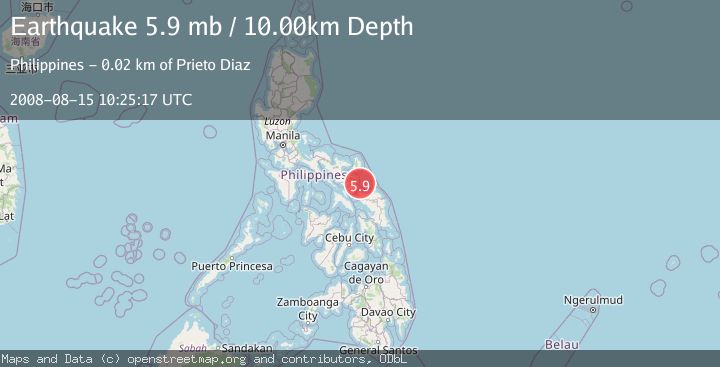
Earthquake SAMAR, PHILIPPINES
Fri, 15 Aug 2008 10:25:17 GMT
Time17 years ago
Location
12.9500, 124.3700
Depth
10.0 KM
Event Summary
A 5.9 magnitude earthquake struck on SAMAR, PHILIPPINES, at Fri, 15 Aug 2008 10:25:17 GMT. Depth: 10km. Reviewed by EMSC seismologists, this moderate quake occurred at a magnitude type of mb.
Magnitude
5.9
mb
Source
EMSC
Intensity
-
Agency Reports
1 Sources| Source | Magnitude | Depth | Time |
|---|---|---|---|
| EMSCPrimary | 5.9 | 10 km | 17 years ago |
Earthquake Details
AutomaticEvent IDemsc_EMSC_20080815_0000037
Tsunami PotentialNo
Magnitude Typemb
Nearest Places
- 17.6 km
- 19.9 km
- 21.5 km
- 21.6 km
- 22.3 km
Comments
Join the discussion about this event.
Latest Earthquakes
1.2Mag
Fox Islands, Aleutian Islands, Alaska
Time2 minutes ago
Depth7.08 km
SourceVYT (Automatic)
1.1Mag
4 km W of Lake Henshaw, CA
Time7 minutes ago
Depth11.92 km
SourceUSGS (Automatic)
2.4Mag
Northern Territory, Australia
Time7 minutes ago
Depth444.34 km
SourceVYT (Automatic)
3.2Mag
Northern Molucca Sea
Time8 minutes ago
Depth35.14 km
SourceBMKG
1.3Mag
western Texas
Time9 minutes ago
Depth12.33 km
SourceVYT (Automatic)
Nearby Earthquakes
5.2Mag
CATANDUANES, PHILIPPINES
Time17 years ago
Depth44.00 km
SourceEMSC (Automatic)
5.1Mag
SAMAR, PHILIPPINES
Time17 years ago
Depth100.00 km
SourceEMSC (Automatic)
4.0Mag
CATANDUANES, PHILIPPINES
Time4 months ago
Depth94.70 km
SourceNEIC (Automatic)
5.4Mag
CATANDUANES, PHILIPPINES
Time5 years ago
Depth79.00 km
SourceEMSC (Automatic)
3.0Mag
CATANDUANES, PHILIPPINES
Time2 years ago
Depth9.00 km
SourcePIVS (Automatic)