Earthquake SAMOA ISLANDS REGION
Tue, 16 Sep 2008 09:46:59 GMT
Time17 years ago
Location
-16.6100, -172.5900
Depth
40.0 KM
Event Summary
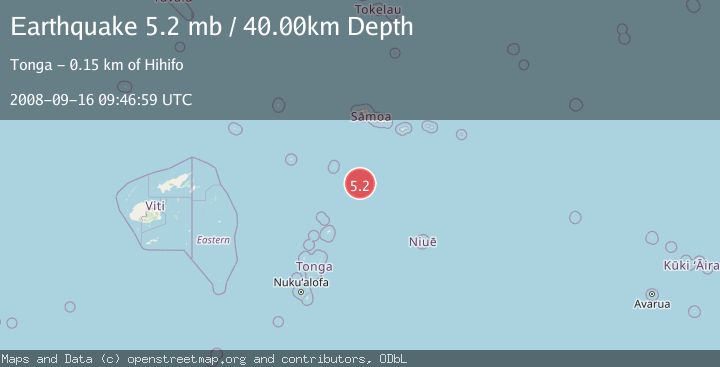
A 5.2 magnitude earthquake struck on SAMOA ISLANDS REGION, at Tue, 16 Sep 2008 09:46:59 GMT. Depth: 40km. Reviewed by EMSC seismologists, this moderate quake occurred at a magnitude type of mb.
Magnitude
5.2
mb
Source
EMSC
Intensity
-
Agency Reports
1 Sources| Source | Magnitude | Depth | Time |
|---|---|---|---|
| EMSCPrimary | 5.2 | 40 km | 17 years ago |
Earthquake Details
AutomaticEvent IDemsc_EMSC_20080916_0000058
Tsunami PotentialNo
Magnitude Typemb
Nearest Places
- 140.3 km
- 141.3 km
- 141.4 km
- 141.8 km
- 142.7 km
Comments
Join the discussion about this event.
Latest Earthquakes
0.8Mag
Southern Alaska
Time2 minutes ago
Depth5.00 km
SourceVYT (Automatic)
2.1Mag
Sweden
Time7 minutes ago
Depth0.00 km
SourceVYT (Automatic)
1.6Mag
western Texas
Time8 minutes ago
Depth0.00 km
SourceVYT (Automatic)
2.8Mag
Java, Indonesia
Time8 minutes ago
Depth26.25 km
SourceVYT (Automatic)
2.0Mag
WESTERN TEXAS
Time17 minutes ago
Depth15.10 km
SourceTX (Automatic)
Nearby Earthquakes
5.3Mag
SAMOA ISLANDS REGION
Time16 years ago
Depth10.00 km
SourceEMSC (Automatic)
5.2Mag
SAMOA ISLANDS REGION
Time20 years ago
Depth33.00 km
SourceEMSC (Automatic)
5.0Mag
SAMOA ISLANDS REGION
Time15 years ago
Depth10.00 km
SourceEMSC (Automatic)
5.5Mag
SAMOA ISLANDS REGION
Time19 years ago
Depth33.00 km
SourceEMSC (Automatic)
5.3Mag
SAMOA ISLANDS REGION
Time20 years ago
Depth33.00 km
SourceEMSC (Automatic)