Earthquake SIMEULUE, INDONESIA
Wed, 04 Mar 2009 10:56:44 GMT
Time16 years ago
Location
2.8600, 95.4000
Depth
30.0 KM
Event Summary
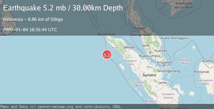
A 5.2 magnitude earthquake struck on SIMEULUE, INDONESIA, at Wed, 04 Mar 2009 10:56:44 GMT. Depth: 30km. Reviewed by EMSC seismologists, this moderate quake occurred at a magnitude type of mb.
Magnitude
5.2
mb
Source
EMSC
Intensity
-
Agency Reports
1 Sources| Source | Magnitude | Depth | Time |
|---|---|---|---|
| EMSCPrimary | 5.2 | 30 km | 16 years ago |
Earthquake Details
AutomaticEvent IDemsc_EMSC_20090304_0000055
Tsunami PotentialNo
Magnitude Typemb
Nearest Places
- Pulau Salaut-besar12.8 km
- Pulau-pulau Kokos15.3 km
- Pulau Salaut Kecil17.4 km
- Tanjung Sembeu33.9 km
- Ujung Alavan35.0 km
Comments
Join the discussion about this event.
Latest Earthquakes
1.0Mag
8 km WNW of The Geysers, CA
Time4 minutes ago
Depth0.69 km
SourceUSGS (Automatic)
2.3Mag
SAN FRANCISCO BAY AREA, CALIF.
Time7 minutes ago
Depth8.70 km
SourceNC (Automatic)
2.1Mag
WESTERN TEXAS
Time9 minutes ago
Depth0.00 km
SourceTX (Automatic)
1.9Mag
Tarapaca, Chile
Time13 minutes ago
Depth0.00 km
SourceVYT (Automatic)
1.0Mag
11 km SW of Anza, CA
Time16 minutes ago
Depth8.49 km
SourceUSGS (Automatic)
Nearby Earthquakes
4.0Mag
SIMEULUE, INDONESIA
Time4 years ago
Depth89.00 km
SourceDJA (Automatic)
5.1Mag
SIMEULUE, INDONESIA
Time9 years ago
Depth30.00 km
SourceEMSC (Automatic)
5.1Mag
SIMEULUE, INDONESIA
Time4 months ago
Depth30.00 km
SourceEMSC (Automatic)
5.1Mag
SIMEULUE, INDONESIA
Time20 years ago
Depth40.00 km
SourceEMSC (Automatic)
5.0Mag
SIMEULUE, INDONESIA
Time9 years ago
Depth30.00 km
SourceEMSC (Automatic)