Earthquake SAMOA ISLANDS REGION
Tue, 29 Sep 2009 18:08:27 GMT
Time16 years ago
Location
-15.6800, -172.0000
Depth
33.0 KM
Event Summary
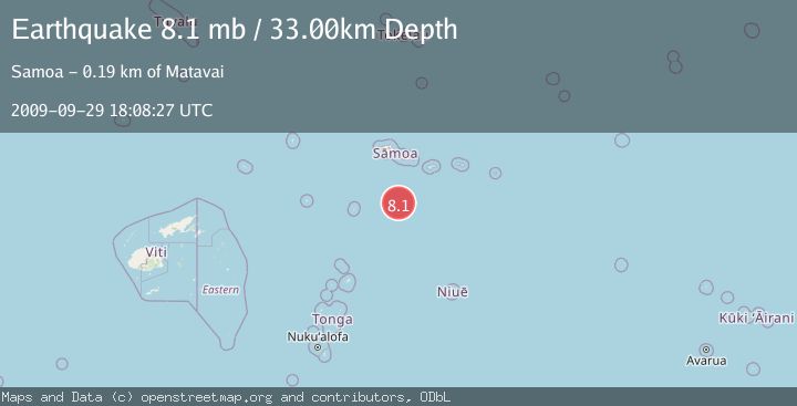
A 8.1 magnitude earthquake struck on SAMOA ISLANDS REGION, at Tue, 29 Sep 2009 18:08:27 GMT. Depth: 33km. Reviewed by EMSC seismologists, this major quake occurred at a magnitude type of mb.
Magnitude
8.1
mb
Source
EMSC
Intensity
-
Agency Reports
1 Sources| Source | Magnitude | Depth | Time |
|---|---|---|---|
| EMSCPrimary | 8.1 | 10 km | 16 years ago |
Earthquake Details
AutomaticEvent IDemsc_EMSC_20090929_0000030
Tsunami PotentialNo
Magnitude Typemb
Nearest Places
- 171.3 km
- 171.3 km
- 171.3 km
- 175.9 km
- 184.1 km
Comments
Join the discussion about this event.
Latest Earthquakes
3.5Mag
AEGEAN SEA
Time5 minutes ago
Depth5.00 km
SourceNOA (Automatic)
2.7Mag
Fox Islands, Aleutian Islands, Alaska
Time8 minutes ago
Depth0.00 km
SourceVYT (Automatic)
2.4Mag
Alaska Peninsula
Time9 minutes ago
Depth27.34 km
SourceVYT (Automatic)
3.2Mag
Fox Islands, Aleutian Islands, Alaska
Time10 minutes ago
Depth19.17 km
SourceVYT (Automatic)
2.2Mag
51 km N of Petersville, Alaska
Time11 minutes ago
Depth89.30 km
SourceUSGS (Automatic)
Nearby Earthquakes
5.3Mag
SAMOA ISLANDS REGION
Time6 years ago
Depth2.00 km
SourceEMSC (Automatic)
5.3Mag
SAMOA ISLANDS REGION
Time20 years ago
Depth40.00 km
SourceEMSC (Automatic)
5.0Mag
SAMOA ISLANDS REGION
Time13 years ago
Depth2.00 km
SourceEMSC (Automatic)
5.2Mag
SAMOA ISLANDS REGION
Time16 years ago
Depth10.00 km
SourceEMSC (Automatic)
5.0Mag
SAMOA ISLANDS REGION
Time7 years ago
Depth10.00 km
SourceEMSC (Automatic)