Earthquake SAMOA ISLANDS REGION
Fri, 02 Oct 2009 12:08:30 GMT
Time16 years ago
Location
-16.4200, -172.6800
Depth
2.0 KM
Event Summary
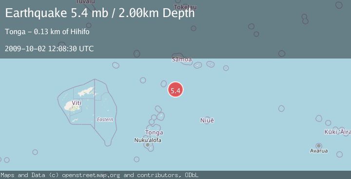
A 5.4 magnitude earthquake struck on SAMOA ISLANDS REGION, at Fri, 02 Oct 2009 12:08:30 GMT. Depth: 2km. Reviewed by EMSC seismologists, this moderate quake occurred at a magnitude type of mb.
Magnitude
5.4
mb
Source
EMSC
Intensity
-
Agency Reports
1 Sources| Source | Magnitude | Depth | Time |
|---|---|---|---|
| EMSCPrimary | 5.4 | 2 km | 16 years ago |
Earthquake Details
AutomaticEvent IDemsc_EMSC_20091002_0000036
Tsunami PotentialNo
Magnitude Typemb
Nearest Places
- 122.9 km
- 123.2 km
- 123.8 km
- 124.2 km
- 124.3 km
Comments
Join the discussion about this event.
Latest Earthquakes
1.9Mag
Southern California
Time6 minutes ago
Depth11.11 km
SourceVYT (Automatic)
1.9Mag
Sweden
Time8 minutes ago
Depth11.84 km
SourceVYT (Automatic)
0.8Mag
9 km NNW of Perryville, Alaska
Time10 minutes ago
Depth118.40 km
SourceUSGS (Automatic)
0.5Mag
Northern Territory, Australia
Time13 minutes ago
Depth5.00 km
SourceVYT (Automatic)
3.5Mag
OFF E. COAST OF N. ISLAND, N.Z.
Time16 minutes ago
Depth207.40 km
SourceGNS (Automatic)
Nearby Earthquakes
5.6Mag
SAMOA ISLANDS REGION
Time18 years ago
Depth33.00 km
SourceEMSC (Automatic)
5.3Mag
SAMOA ISLANDS REGION
Time20 years ago
Depth33.00 km
SourceEMSC (Automatic)
5.0Mag
SAMOA ISLANDS REGION
Time15 years ago
Depth10.00 km
SourceEMSC (Automatic)
5.5Mag
SAMOA ISLANDS REGION
Time19 years ago
Depth33.00 km
SourceEMSC (Automatic)
5.2Mag
SAMOA ISLANDS REGION
Time20 years ago
Depth33.00 km
SourceEMSC (Automatic)