Earthquake MOLUCCA SEA
Mon, 07 Jun 2010 15:27:15 GMT
Time15 years ago
Location
-0.2500, 124.6400
Depth
87.0 KM
Event Summary
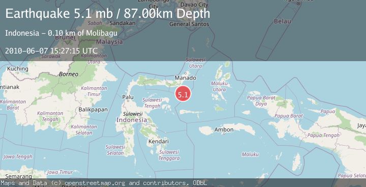
A 5.1 magnitude earthquake struck on MOLUCCA SEA, at Mon, 07 Jun 2010 15:27:15 GMT. Depth: 87km. Reviewed by EMSC seismologists, this moderate quake occurred at a magnitude type of mb.
Magnitude
5.1
mb
Source
EMSC
Intensity
-
Agency Reports
1 Sources| Source | Magnitude | Depth | Time |
|---|---|---|---|
| EMSCPrimary | 5.1 | 87 km | 15 years ago |
Earthquake Details
AutomaticEvent IDemsc_EMSC_20100607_0000038
Tsunami PotentialNo
Magnitude Typemb
Nearest Places
- Gorontalo Basin71.2 km
- Pulau Lampu79.6 km
- Tanjung Payunga80.0 km
- Libuton Babi80.5 km
- Luok Monggarang80.5 km
Comments
Join the discussion about this event.
Latest Earthquakes
1.6Mag
Kenai Peninsula, Alaska
Time4 minutes ago
Depth42.60 km
SourceVYT (Automatic)
2.4Mag
Finland
Time6 minutes ago
Depth301.88 km
SourceVYT (Automatic)
1.2Mag
Alaska Peninsula
Time7 minutes ago
Depth0.12 km
SourceVYT (Automatic)
4.1Mag
NEAR COAST OF NORTHERN PERU
Time12 minutes ago
Depth35.00 km
SourceLIM (Automatic)
3.1Mag
DODECANESE IS.-TURKEY BORDER REG
Time13 minutes ago
Depth4.10 km
SourceKOERI (Automatic)
Nearby Earthquakes
5.0Mag
MOLUCCA SEA
Time18 years ago
Depth73.00 km
SourceEMSC (Automatic)
5.1Mag
MOLUCCA SEA
Time1 year ago
Depth71.00 km
SourceEMSC (Automatic)
5.0Mag
MOLUCCA SEA
Time14 years ago
Depth70.00 km
SourceEMSC (Automatic)
5.4Mag
MOLUCCA SEA
Time2 years ago
Depth55.00 km
SourceEMSC (Automatic)
4.3Mag
Southern Molucca Sea
Time3 weeks ago
Depth5.64 km
SourceBMKG (Automatic)