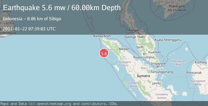
Earthquake OFF W COAST OF NORTHERN SUMATRA
Sat, 22 Jan 2011 07:39:03 GMT
Time15 years ago
Location
3.3100, 95.6400
Depth
60.0 KM
Event Summary
A 5.6 magnitude earthquake struck on OFF W COAST OF NORTHERN SUMATRA, at Sat, 22 Jan 2011 07:39:03 GMT. Depth: 60km. Reviewed by EMSC seismologists, this moderate quake occurred at a magnitude type of mw.
Magnitude
5.6
mw
Source
EMSC
Intensity
-
Agency Reports
1 Sources| Source | Magnitude | Depth | Time |
|---|---|---|---|
| EMSCPrimary | 5.6 | 60 km | 15 years ago |
Earthquake Details
AutomaticEvent IDemsc_EMSC_20110122_0000026
Tsunami PotentialNo
Magnitude Typemw
Nearest Places
- Pulau Salaut Kecil42.1 km
- Pulau-pulau Kokos44.2 km
- Pulau Ina44.6 km
- Ujung Dewa46.0 km
- Gelokepang46.1 km
Comments
Join the discussion about this event.
Latest Earthquakes
1.3Mag
54 km WNW of Toyah, Texas
Time21 hours ago
Depth0.00 km
SourceUSGS (Automatic)
2.9Mag
Oruro, Bolivia
Time21 hours ago
Depth189.21 km
SourceVYT (Automatic)
3.4Mag
OFF COAST OF COSTA RICA
Time21 hours ago
Depth10.00 km
SourceINET (Automatic)
2.0Mag
Central Alaska
Time21 hours ago
Depth56.15 km
SourceVYT (Automatic)
2.6Mag
Antofagasta, Chile
Time21 hours ago
Depth0.00 km
SourceVYT (Automatic)
Nearby Earthquakes
5.0Mag
OFF W COAST OF NORTHERN SUMATRA
Time20 years ago
Depth60.00 km
SourceEMSC (Automatic)
3.1Mag
Off West Coast of Northern Sumatra
Time2 weeks ago
Depth3.90 km
SourceBMKG (Automatic)
5.1Mag
OFF W COAST OF NORTHERN SUMATRA
Time21 years ago
Depth33.00 km
SourceEMSC (Automatic)
9.3Mag
OFF W COAST OF NORTHERN SUMATRA
Time21 years ago
Depth10.00 km
SourceEMSC (Automatic)
5.8Mag
OFF W COAST OF NORTHERN SUMATRA
Time21 years ago
Depth33.00 km
SourceEMSC (Automatic)