Earthquake KERMADEC ISLANDS REGION
Thu, 28 Jul 2011 04:26:13 GMT
Time14 years ago
Location
-29.2400, -176.0700
Depth
15.0 KM
Event Summary
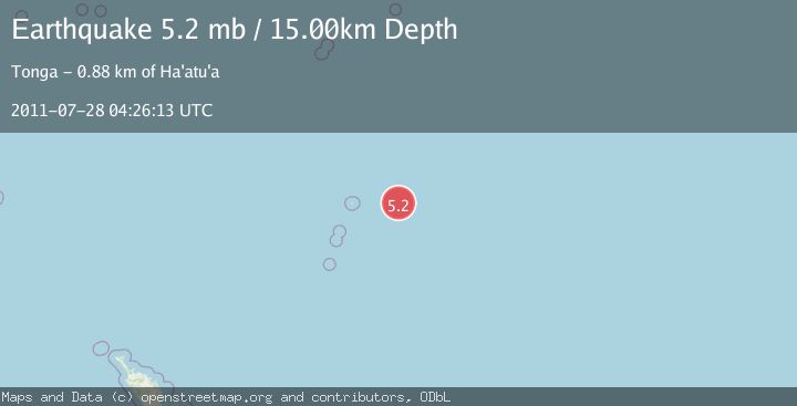
A 5.2 magnitude earthquake struck on KERMADEC ISLANDS REGION, at Thu, 28 Jul 2011 04:26:13 GMT. Depth: 15km. Reviewed by EMSC seismologists, this moderate quake occurred at a magnitude type of mb.
Magnitude
5.2
mb
Source
EMSC
Intensity
-
Agency Reports
1 Sources| Source | Magnitude | Depth | Time |
|---|---|---|---|
| EMSCPrimary | 5.2 | 15 km | 14 years ago |
Earthquake Details
AutomaticEvent IDemsc_EMSC_20110728_0000004
Tsunami PotentialNo
Magnitude Typemb
Nearest Places
- 123.4 km
- 169.5 km
- 169.5 km
- 169.5 km
- 171.1 km
Comments
Join the discussion about this event.
Latest Earthquakes
0.8Mag
6 km NW of The Geysers, CA
Time6 minutes ago
Depth3.38 km
SourceUSGS (Automatic)
1.8Mag
Sulawesi, Indonesia
Time10 minutes ago
Depth6.47 km
SourceVYT (Automatic)
2.6Mag
Alaska Peninsula
Time12 minutes ago
Depth67.50 km
SourceVYT (Automatic)
0.6Mag
6 km NW of The Geysers, CA
Time12 minutes ago
Depth3.63 km
SourceUSGS (Automatic)
3.3Mag
northern Sumatra, Indonesia
Time13 minutes ago
Depth0.00 km
SourceVYT (Automatic)
Nearby Earthquakes
5.3Mag
KERMADEC ISLANDS REGION
Time4 years ago
Depth10.00 km
SourceEMSC (Automatic)
5.1Mag
KERMADEC ISLANDS REGION
Time14 years ago
Depth45.00 km
SourceEMSC (Automatic)
5.5Mag
KERMADEC ISLANDS REGION
Time14 years ago
Depth10.00 km
SourceEMSC (Automatic)
5.2Mag
KERMADEC ISLANDS REGION
Time14 years ago
Depth10.00 km
SourceEMSC (Automatic)
5.0Mag
KERMADEC ISLANDS REGION
Time14 years ago
Depth10.00 km
SourceEMSC (Automatic)