Earthquake SOUTH OF KERMADEC ISLANDS
Tue, 06 Sep 2011 10:51:33 GMT
Time14 years ago
Location
-34.1300, 179.5800
Depth
10.0 KM
Event Summary
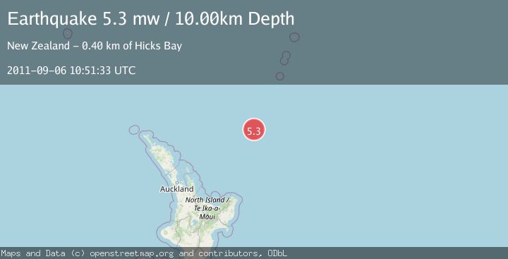
A 5.3 magnitude earthquake struck on SOUTH OF KERMADEC ISLANDS, at Tue, 06 Sep 2011 10:51:33 GMT. Depth: 10km. Reviewed by EMSC seismologists, this moderate quake occurred at a magnitude type of mw.
Magnitude
5.3
mw
Source
EMSC
Intensity
-
Agency Reports
1 Sources| Source | Magnitude | Depth | Time |
|---|---|---|---|
| EMSCPrimary | 5.3 | 10 km | 14 years ago |
Earthquake Details
AutomaticEvent IDemsc_EMSC_20110906_0000027
Tsunami PotentialNo
Magnitude Typemw
Nearest Places
- Ngātoroirangi Seamount48.2 km
- Kibblewhite Seamount59.3 km
- Brothers Seamount95.5 km
- James Healy Seamount109.2 km
- Giljanes Seamount116.5 km
Comments
Join the discussion about this event.
Latest Earthquakes
1.5Mag
Southern Yukon Territory, Canada
Time3 minutes ago
Depth3.42 km
SourceVYT (Automatic)
1.3Mag
Tarapaca, Chile
Time10 minutes ago
Depth28.81 km
SourceVYT (Automatic)
1.6Mag
53 km SSE of Whites City, New Mexico
Time11 minutes ago
Depth0.00 km
SourceUSGS (Automatic)
2.0Mag
Minahassa Peninsula, Sulawesi
Time12 minutes ago
Depth2.34 km
SourceBMKG
2.6Mag
ARUNACHAL PRADESH, INDIA
Time13 minutes ago
Depth10.00 km
SourceNDI (Automatic)
Nearby Earthquakes
5.2Mag
SOUTH OF KERMADEC ISLANDS
Time14 years ago
Depth10.00 km
SourceEMSC (Automatic)
4.0Mag
SOUTH OF KERMADEC ISLANDS
Time3 years ago
Depth253.00 km
SourceGNS (Automatic)
4.0Mag
SOUTH OF KERMADEC ISLANDS
Time3 years ago
Depth279.00 km
SourceGNS (Automatic)
5.1Mag
SOUTH OF KERMADEC ISLANDS
Time4 years ago
Depth10.00 km
SourceNEIC (Automatic)
5.0Mag
SOUTH OF KERMADEC ISLANDS
Time6 years ago
Depth10.00 km
SourceEMSC (Automatic)