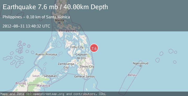
Earthquake PHILIPPINE ISLANDS REGION
Fri, 31 Aug 2012 13:40:32 GMT
Time13 years ago
Location
10.4600, 126.7900
Depth
40.0 KM
Event Summary
A 7.6 magnitude earthquake struck on PHILIPPINE ISLANDS REGION, at Fri, 31 Aug 2012 13:40:32 GMT. Depth: 40km. Reviewed by EMSC seismologists, this major quake occurred at a magnitude type of mb.
Magnitude
7.6
mb
Source
EMSC
Intensity
-
Agency Reports
1 Sources| Source | Magnitude | Depth | Time |
|---|---|---|---|
| EMSCPrimary | 7.6 | 20 km | 13 years ago |
Earthquake Details
AutomaticEvent IDemsc_EMSC_20120831_0000040
Tsunami PotentialNo
Magnitude Typemb
Nearest Places
- Emden Deep29.6 km
- Homonhon Seamount49.6 km
- Suluan Seamount52.3 km
- Candulo Ridge73.0 km
- Arena Point90.7 km
Comments
Join the discussion about this event.
Latest Earthquakes
3.0Mag
Antofagasta, Chile
Time51 seconds ago
Depth108.89 km
SourceVYT (Automatic)
1.7Mag
STRAIT OF GIBRALTAR
Time10 minutes ago
Depth15.80 km
SourceIGN (Automatic)
3.2Mag
Croatia-Bosnia and Herzegovina border region
Time14 minutes ago
Depth63.84 km
SourceVYT (Automatic)
1.0Mag
Southern Alaska
Time18 minutes ago
Depth13.43 km
SourceVYT (Automatic)
2.7Mag
Southeastern Alaska
Time19 minutes ago
Depth138.92 km
SourceVYT (Automatic)
Nearby Earthquakes
5.7Mag
PHILIPPINE ISLANDS REGION
Time13 years ago
Depth40.00 km
SourceEMSC (Automatic)
5.2Mag
PHILIPPINE ISLANDS REGION
Time13 years ago
Depth29.00 km
SourceEMSC (Automatic)
4.0Mag
PHILIPPINE ISLANDS REGION
Time11 months ago
Depth10.00 km
SourcePIVS (Automatic)
3.0Mag
PHILIPPINE ISLANDS REGION
Time2 years ago
Depth1.00 km
SourcePIVS (Automatic)
4.0Mag
PHILIPPINE ISLANDS REGION
Time6 years ago
Depth1.00 km
SourcePIVS (Automatic)