Earthquake PHILIPPINE ISLANDS REGION
Thu, 13 Apr 2017 16:05:50 GMT
Time8 years ago
Location
5.8200, 127.3300
Depth
30.0 KM
Event Summary
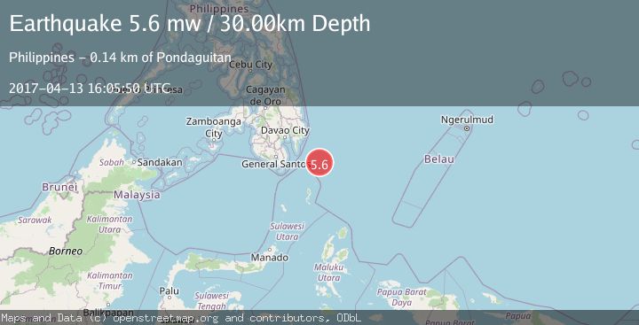
A 5.6 magnitude earthquake struck on PHILIPPINE ISLANDS REGION, at Thu, 13 Apr 2017 16:05:50 GMT. Depth: 30km. Reviewed by EMSC seismologists, this moderate quake occurred at a magnitude type of mw.
Magnitude
5.6
mw
Source
EMSC
Intensity
-
Agency Reports
1 Sources| Source | Magnitude | Depth | Time |
|---|---|---|---|
| EMSCPrimary | 5.6 | 30 km | 8 years ago |
Earthquake Details
AutomaticEvent IDemsc_EMSC_20170413_0000075
Tsunami PotentialNo
Magnitude Typemw
Nearest Places
- Tanjung Dapapa86.7 km
- Desa Pulau Miangas87.6 km
- Kecamatan Miangas87.6 km
- Pulau Miangas87.6 km
- Miangas88.3 km
Comments
Join the discussion about this event.
Latest Earthquakes
3.6Mag
Offshore Crete, Greece
Time4 minutes ago
Depth76.42 km
SourceVYT (Automatic)
1.8Mag
Southeastern Alaska
Time11 minutes ago
Depth0.49 km
SourceVYT (Automatic)
1.8Mag
British Columbia, Canada
Time12 minutes ago
Depth0.00 km
SourceVYT (Automatic)
2.0Mag
SAN FRANCISCO BAY AREA, CALIF.
Time12 minutes ago
Depth18.40 km
SourceNC (Automatic)
2.2Mag
Sumbawa Region, Indonesia
Time13 minutes ago
Depth176.31 km
SourceBMKG
Nearby Earthquakes
5.2Mag
PHILIPPINE ISLANDS REGION
Time8 years ago
Depth10.00 km
SourceEMSC (Automatic)
5.7Mag
PHILIPPINE ISLANDS REGION
Time8 years ago
Depth10.00 km
SourceEMSC (Automatic)
3.0Mag
PHILIPPINE ISLANDS REGION
Time2 years ago
Depth33.00 km
SourcePIVS (Automatic)
5.0Mag
PHILIPPINE ISLANDS REGION
Time8 years ago
Depth40.00 km
SourceEMSC (Automatic)
5.0Mag
PHILIPPINE ISLANDS REGION
Time16 years ago
Depth60.00 km
SourceEMSC (Automatic)