Earthquake SOLOMON ISLANDS
Mon, 27 Jan 2020 05:02:02 GMT
Time6 years ago
Location
-10.0500, 161.0100
Depth
30.0 KM
Event Summary
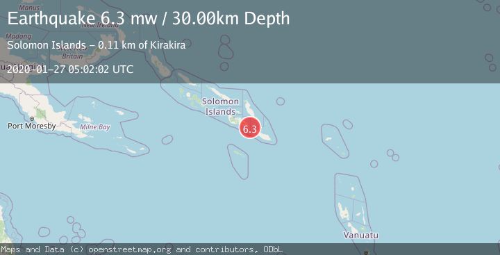
A 6.3 magnitude earthquake struck on SOLOMON ISLANDS, at Mon, 27 Jan 2020 05:02:02 GMT. Depth: 30km. Reviewed by EMSC seismologists, this strong quake occurred at a magnitude type of mw.
Magnitude
6.3
mw
Source
EMSC
Intensity
-
Agency Reports
1 Sources| Source | Magnitude | Depth | Time |
|---|---|---|---|
| EMSCPrimary | 6.3 | 30 km | 6 years ago |
Earthquake Details
AutomaticEvent IDemsc_EMSC_20200127_0000047
Tsunami PotentialNo
Magnitude Typemw
Nearest Places
- 22.8 km
- 24.2 km
- 25.3 km
- 4Kasa25.7 km
- 25.7 km
Comments
Join the discussion about this event.
Latest Earthquakes
2.9Mag
Sumba Region, Indonesia
Time3 minutes ago
Depth22.02 km
SourceBMKG
3.0Mag
GREECE
Time6 minutes ago
Depth5.00 km
SourceNOA (Automatic)
3.0Mag
Offshore southern Greece
Time6 minutes ago
Depth157.71 km
SourceVYT (Automatic)
2.8Mag
South of Bali, Indonesia
Time8 minutes ago
Depth19.68 km
SourceBMKG
2.2Mag
British Columbia, Canada
Time8 minutes ago
Depth0.00 km
SourceVYT (Automatic)
Nearby Earthquakes
5.2Mag
SOLOMON ISLANDS
Time7 years ago
Depth48.00 km
SourceEMSC (Automatic)
5.0Mag
SOLOMON ISLANDS
Time12 years ago
Depth40.00 km
SourceEMSC (Automatic)
5.3Mag
SOLOMON ISLANDS
Time8 years ago
Depth30.00 km
SourceEMSC (Automatic)
5.4Mag
SOLOMON ISLANDS
Time9 years ago
Depth30.00 km
SourceEMSC (Automatic)
5.1Mag
SOLOMON ISLANDS
Time15 years ago
Depth90.00 km
SourceEMSC (Automatic)